Mouse Mat > Aerial Photography > Austria
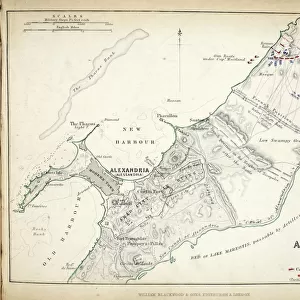
Mouse Mat : Map of the Battle of Zurich, published by William Blackwood and Sons, Edinburgh & London


![]()
Home Decor from Fine Art Finder
Map of the Battle of Zurich, published by William Blackwood and Sons, Edinburgh & London
746922 Map of the Battle of Zurich, published by William Blackwood and Sons, Edinburgh & London, 1848 (hand-coloured engraving) by Johnston, Alexander Keith (1804-71); Private Collection; (add.info.: First Battle of Zurich (4-7 June 1799)
); The Stapleton Collection; Scottish, out of copyright
Media ID 23168520
© The Stapleton Collection / Bridgeman Images
Aerial View Armies French Revolutionary Wars Mapping Positions War Of The Second Coalition
Mouse Pad
Bring some life into your office, or create a heartfelt gift, with a personalised deluxe Mouse Mat. Made of high-density black foam with a tough, stain-resistant inter-woven cloth cover they will brighten up any home or corporate office.
Archive quality photographic print in a durable wipe clean mouse mat with non slip backing. Works with all computer mice
Estimated Product Size is 24.2cm x 19.7cm (9.5" x 7.8")
These are individually made so all sizes are approximate
Artwork printed orientated as per the preview above, with landscape (horizontal) or portrait (vertical) orientation to match the source image.
FEATURES IN THESE COLLECTIONS
> Fine Art Finder
> Artists
> Alexander Keith Johnston
> Fine Art Finder
> Maps (celestial & Terrestrial)
> Aerial Photography
> Austria
> Aerial Photography
> Related Images
> Aerial Photography
> Scotland
> Aerial Photography
> Switzerland
> Arts
> Artists
> A
> William Alexander
> Arts
> Artists
> K
> William Keith
> Europe
> Austria
> Aerial Views
EDITORS COMMENTS
This print showcases a historical treasure, the "Map of the Battle of Zurich" meticulously published by William Blackwood and Sons in 1848. Crafted with utmost precision and attention to detail, this hand-coloured engraving by Alexander Keith Johnston offers an aerial view of the First Battle of Zurich (4-7 June 1799) during the French Revolutionary Wars. Immerse yourself in this remarkable cartographic masterpiece as it unveils the strategic positions held by both Austrian and French forces. The map provides a comprehensive overview of the Swiss campaign, shedding light on one of history's most significant conflicts – the War of the Second Coalition. As you explore this intricately designed print, marvel at how it captures not only topographical features but also depicts armies engaged in battle. Each stroke tells a story; each contour represents a tactical move that shaped Switzerland's fate during this tumultuous period. The artistry behind this engraving is truly awe-inspiring. Its vibrant colors bring life to an otherwise black-and-white era, transporting us back to early 19th-century Europe. This piece from The Stapleton Collection serves as a testament to Johnston's mastery in mapping techniques and his dedication to preserving historical events through art. Whether you are an enthusiast for military history or simply appreciate fine craftsmanship, let your imagination soar as you delve into this extraordinary print capturing a pivotal moment in time.
MADE IN AUSTRALIA
Safe Shipping with 30 Day Money Back Guarantee
FREE PERSONALISATION*
We are proud to offer a range of customisation features including Personalised Captions, Color Filters and Picture Zoom Tools
SECURE PAYMENTS
We happily accept a wide range of payment options so you can pay for the things you need in the way that is most convenient for you
* Options may vary by product and licensing agreement. Zoomed Pictures can be adjusted in the Cart.