Mouse Mat > Europe > Slovakia > Maps
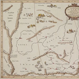
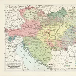
Mouse Mat : Map of the kingdom of Hungary, printed by Godfried (coloured engraving)
")

![]()
Home Decor from Fine Art Finder
Map of the kingdom of Hungary, printed by Godfried (coloured engraving)
CZA229119 Map of the kingdom of Hungary, printed by Godfried (coloured engraving) by Lipszki, Jan (fl.1590-1610) (after); 69x46 cm; Czartoryski Museum, Cracow, Poland; Hungarian, out of copyright
Media ID 18253703
© Czartoryski Museum, Cracow, Poland / Bridgeman Images
Mouse Pad
Bring some life into your office, or create a heartfelt gift, with a personalised deluxe Mouse Mat. Made of high-density black foam with a tough, stain-resistant inter-woven cloth cover they will brighten up any home or corporate office.
Archive quality photographic print in a durable wipe clean mouse mat with non slip backing. Works with all computer mice
Estimated Product Size is 19.7cm x 24.2cm (7.8" x 9.5")
These are individually made so all sizes are approximate
Artwork printed orientated as per the preview above, with landscape (horizontal) or portrait (vertical) orientation to match the source image.
FEATURES IN THESE COLLECTIONS
> Fine Art Finder
> Maps (celestial & Terrestrial)
> Europe
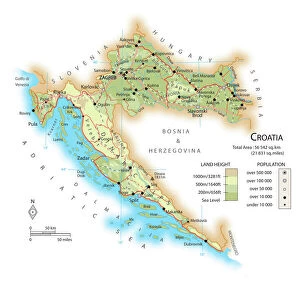
> Croatia
> Related Images
> Europe
> Hungary
> Related Images
> Europe
> Poland
> Related Images
EDITORS COMMENTS
This print showcases a beautifully detailed map of the kingdom of Hungary, printed by Godfried in the form of a coloured engraving. Created by Jan Lipszki, an esteemed cartographer who flourished between 1590 and 1610, this historic piece measures 69x46 cm and is currently housed in the prestigious Czartoryski Museum in Cracow, Poland. The map takes us on a journey through time as we explore the intricate borders and landmarks that defined the kingdom during the 16th and 17th centuries. With its vibrant hues and meticulous attention to detail, it offers a glimpse into Hungary's rich history. Notably encompassing regions such as Croatia and Slovakia, this map serves as both a geographical reference point and a testament to the cultural diversity within Hungary's borders. It highlights how these lands were interconnected during this era while also showcasing their unique characteristics. As we admire this remarkable artwork from Fine Art Finder, let us appreciate not only its aesthetic beauty but also its historical significance. Through maps like these, we gain insight into past civilizations' understanding of their world—a visual representation that transcends time itself.
MADE IN AUSTRALIA
Safe Shipping with 30 Day Money Back Guarantee
FREE PERSONALISATION*
We are proud to offer a range of customisation features including Personalised Captions, Color Filters and Picture Zoom Tools
SECURE PAYMENTS
We happily accept a wide range of payment options so you can pay for the things you need in the way that is most convenient for you
* Options may vary by product and licensing agreement. Zoomed Pictures can be adjusted in the Cart.