Mouse Mat > Arts > Artists > C > William Collins
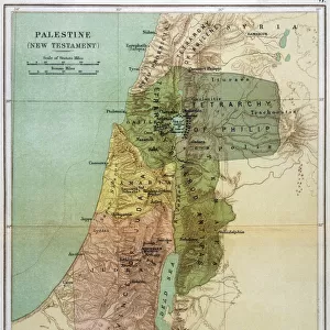
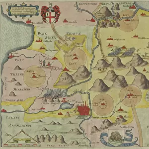
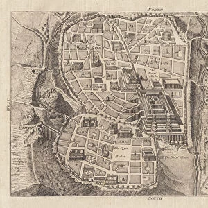
Mouse Mat : Canaan as it was divided between the twelve tribes of Israel (colour litho)
")

![]()
Home Decor from Fine Art Finder
Canaan as it was divided between the twelve tribes of Israel (colour litho)
KW360490 Canaan as it was divided between the twelve tribes of Israel (colour litho) by English School, (19th century); Private Collection; (add.info.: from The Holy Bible, published by William Collins, Sons & Company, 1869; ); Ken Welsh; English, out of copyright
Media ID 12865750
© www.bridgemanimages.com
Mouse Pad
Bring some life into your office, or create a heartfelt gift, with a personalised deluxe Mouse Mat. Made of high-density black foam with a tough, stain-resistant inter-woven cloth cover they will brighten up any home or corporate office.
Archive quality photographic print in a durable wipe clean mouse mat with non slip backing. Works with all computer mice
Estimated Product Size is 19.7cm x 24.2cm (7.8" x 9.5")
These are individually made so all sizes are approximate
Artwork printed orientated as per the preview above, with landscape (horizontal) or portrait (vertical) orientation to match the source image.
FEATURES IN THESE COLLECTIONS
> Fine Art Finder
> Schools
> English School
> Arts
> Artists
> C
> William Collins
> Asia
> Israel
> Related Images
> Maps and Charts
> Related Images
EDITORS COMMENTS
This vibrant color lithograph showcases the ancient land of Canaan as it was divided between the twelve tribes of Israel. Created by an English School artist in the 19th century, this print offers a glimpse into biblical history and the geographical layout of this sacred region. The intricate details and topographical accuracy make this map a valuable resource for cartography enthusiasts and those interested in Middle Eastern geography. The divisions between each tribe are clearly marked, allowing viewers to visualize how the land was apportioned among the descendants of Jacob. Published in William Collins, Sons & Company's edition of The Holy Bible in 1869, this print holds both historical and religious significance. It serves as a visual aid for understanding biblical narratives that took place within these specific territories. Displayed against a white background, the colors used in this lithograph bring life to Canaan's landscape. Shades of green represent fertile areas while shades of brown depict arid regions. Rivers meander through valleys, connecting various parts of this ancient land. Whether you're studying biblical history or simply appreciate fine art depicting maps and landscapes, this print is sure to captivate your imagination. Its inclusion in private collections speaks to its enduring appeal and value as an artistic representation of Canaan's division among Israel's twelve tribes.
MADE IN AUSTRALIA
Safe Shipping with 30 Day Money Back Guarantee
FREE PERSONALISATION*
We are proud to offer a range of customisation features including Personalised Captions, Color Filters and Picture Zoom Tools
SECURE PAYMENTS
We happily accept a wide range of payment options so you can pay for the things you need in the way that is most convenient for you
* Options may vary by product and licensing agreement. Zoomed Pictures can be adjusted in the Cart.