Mouse Mat > Arts > Still life artwork > Pop art > Digital art
Mouse Mat : Engraved Chart of United States Time Zones, Circa 1883


![]()
Home Decor from Fine Art Storehouse
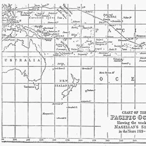
Engraved Chart of United States Time Zones, Circa 1883
Beautifully Illustrated Antique Engraved Victorian Illustration of an Engraved Chart of United States Time Zones and Standard Railway Time, Circa 1883. Source: The Popular Science Monthly, By E.L. and W.J. Youmans. Published in 1885. Original edition from my own archives. Copyright has expired on this artwork. Digitally restored
Unleash your creativity and transform your space into a visual masterpiece!
bauhaus1000
Media ID 14719345
© This content is subject to copyright
Mouse Pad
Bring some life into your office, or create a heartfelt gift, with a personalised deluxe Mouse Mat. Made of high-density black foam with a tough, stain-resistant inter-woven cloth cover they will brighten up any home or corporate office.
Archive quality photographic print in a durable wipe clean mouse mat with non slip backing. Works with all computer mice
Estimated Product Size is 24.2cm x 19.7cm (9.5" x 7.8")
These are individually made so all sizes are approximate
Artwork printed orientated as per the preview above, with landscape (horizontal) or portrait (vertical) orientation to match the source image.
FEATURES IN THESE COLLECTIONS
> Fine Art Storehouse
> Map
> Historical Maps
> Arts
> Contemporary art
> Digital artwork
> Pop art
> Arts
> Contemporary art
> Pop art
> Digital art
> Arts
> Still life artwork
> Pop art
> Digital art
> Arts
> Street art graffiti
> Digital art
> Digital paintings
> Arts
> Street art graffiti
> Digital art
> Pop art
> Arts
> Street art graffiti
> Pop art
> Digital art
> Maps and Charts
> Related Images
> Popular Themes
> Railway Posters
EDITORS COMMENTS
This beautifully illustrated antique print takes us back to the late 19th century, offering a glimpse into the intricate world of timekeeping in the United States. The Engraved Chart of United States Time Zones, Circa 1883 showcases an exquisite Victorian illustration that captures both artistry and functionality. Published in 1885 as part of The Popular Science Monthly by E. L. and W. J. Youmans, this original edition from my personal archives has been digitally restored for preservation. With its copyright expired, this artwork now serves as a valuable historical artifact. The chart depicts the four main time zones - Pacific Time, Mountain Time, Central Time, and Eastern Time - which were established during this era to synchronize railway schedules across vast distances. Each zone is meticulously engraved with delicate details reflecting the unique characteristics of its respective region. As we admire this piece, we are transported back to a time when standardizing time was crucial for efficient travel and communication throughout America's expanding rail network. It reminds us of how far we have come in our modern age where technology seamlessly keeps us connected across multiple time zones. Bauhaus1000's fine art storehouse allows us to appreciate such remarkable pieces from history while celebrating their aesthetic value and cultural significance without commercial intent or use.
MADE IN AUSTRALIA
Safe Shipping with 30 Day Money Back Guarantee
FREE PERSONALISATION*
We are proud to offer a range of customisation features including Personalised Captions, Color Filters and Picture Zoom Tools
SECURE PAYMENTS
We happily accept a wide range of payment options so you can pay for the things you need in the way that is most convenient for you
* Options may vary by product and licensing agreement. Zoomed Pictures can be adjusted in the Cart.