Mouse Mat > Africa > Egypt > Maps
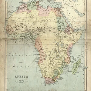
Mouse Mat : Map of Africa 1877


![]()
Home Decor from Fine Art Storehouse
Map of Africa 1877
Warrens Common School Geography 1877
Unleash your creativity and transform your space into a visual masterpiece!
THEPALMER
Media ID 14824571
© This content is subject to copyright
Central Africa East Africa Egypt Madagascar Sahara Somalia South Africa Sudan
Mouse Pad
Bring some life into your office, or create a heartfelt gift, with a personalised deluxe Mouse Mat. Made of high-density black foam with a tough, stain-resistant inter-woven cloth cover they will brighten up any home or corporate office.
Archive quality photographic print in a durable wipe clean mouse mat with non slip backing. Works with all computer mice
Estimated Product Size is 24.2cm x 19.7cm (9.5" x 7.8")
These are individually made so all sizes are approximate
Artwork printed orientated as per the preview above, with landscape (horizontal) or portrait (vertical) orientation to match the source image.
FEATURES IN THESE COLLECTIONS
> Fine Art Storehouse
> Map
> Historical Maps
> Africa
> Egypt
> Related Images
> Africa
> Madagascar
> Maps
> Africa
> Madagascar
> Related Images
> Africa
> Related Images
> Africa
> Somalia
> Related Images
> Africa
> South Africa
> Maps
> Africa
> South Africa
> Related Images
> Africa
> South Sudan
> Maps
EDITORS COMMENTS
In this print titled "Map of Africa 1877" we are transported back in time to the late 19th century, where cartography was a true art form. The intricate details and delicate craftsmanship of this map, sourced from Warrens Common School Geography in 1877, offer us a glimpse into the historical landscape of Africa. The map showcases the vastness and diversity of the African continent during that era. From its northernmost point in Egypt to the southern tip of South Africa, every region is meticulously outlined with precision. Central Africa's dense rainforests contrast with the arid expanse of Sahara desert further north. East Africa's Great Rift Valley stands out as a prominent geographical feature on this vintage representation. As our eyes wander across the map, we encounter Madagascar off the eastern coast—a vibrant island rich in biodiversity and culture. Sudan lies adjacent to Egypt, while Somalia stretches along East Africa's coastline. Each country is labeled with elegant calligraphy, reminding us of an era when penmanship was celebrated as an art form. "The Map of Africa 1877" by THEPALMER invites us to reflect upon how our understanding and perception of geography have evolved over time. It serves as a reminder that maps not only provide navigational guidance but also hold historical significance and cultural value. This stunning print from Fine Art Storehouse transports us back to an age when exploration and discovery were at their peak—where knowledge unfolded through beautifully crafted maps like these—an exquisite piece for any history enthusiast
MADE IN AUSTRALIA
Safe Shipping with 30 Day Money Back Guarantee
FREE PERSONALISATION*
We are proud to offer a range of customisation features including Personalised Captions, Color Filters and Picture Zoom Tools
SECURE PAYMENTS
We happily accept a wide range of payment options so you can pay for the things you need in the way that is most convenient for you
* Options may vary by product and licensing agreement. Zoomed Pictures can be adjusted in the Cart.