Mouse Mat > Maps and Charts > Related Images
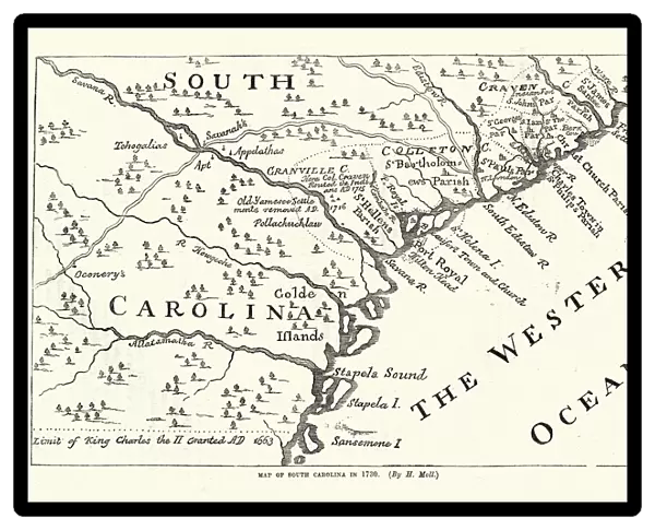
Mouse Mat : Map of South Carolina in 1730, 18th Century
![]()

Home Decor from Fine Art Storehouse
Map of South Carolina in 1730, 18th Century
Vintage engraving of Map of South Carolina in 1730, 18th Century
Unleash your creativity and transform your space into a visual masterpiece!
duncan1890
Media ID 18563428
© of Duncan P Walker
Mouse Pad
Bring some life into your office, or create a heartfelt gift, with a personalised deluxe Mouse Mat. Made of high-density black foam with a tough, stain-resistant inter-woven cloth cover they will brighten up any home or corporate office.
Archive quality photographic print in a durable wipe clean mouse mat with non slip backing. Works with all computer mice
Estimated Product Size is 24.2cm x 19.7cm (9.5" x 7.8")
These are individually made so all sizes are approximate
Artwork printed orientated as per the preview above, with landscape (horizontal) or portrait (vertical) orientation to match the source image.
FEATURES IN THESE COLLECTIONS
> Fine Art Storehouse
> Map
> Historical Maps
> Maps and Charts
> Related Images
EDITORS COMMENTS
This vintage engraving takes us back in time to the early 18th century, offering a glimpse into the rich history of South Carolina. The intricate details and delicate lines of this black and white map transport us to an era when cartography was both an art form and a scientific endeavor. The Map of South Carolina in 1730 showcases the state's geographical features with remarkable precision. From its jagged coastline to its meandering rivers, every contour is meticulously etched onto the paper, revealing a land waiting to be explored. This antique print serves as a testament to the skillful craftsmanship of engravers during that period. As we study this historical artifact, we can't help but marvel at how far we have come since then. The equipment used by cartographers has evolved significantly over time, making maps more accurate and accessible than ever before. Yet there is something undeniably charming about these hand-drawn representations that continue to captivate our imagination. Whether you are a history enthusiast or simply appreciate fine art, this print offers a unique opportunity to connect with South Carolina's past. It invites us on a journey through time, allowing us to trace the footsteps of those who once inhabited this beautiful region. Duncan1890's rendition beautifully captures the essence of this antique map while preserving its authenticity for generations to come. Displayed proudly on any wall, it serves as both an educational tool and a conversation starter - reminding us all of our shared human story woven into the tapestry of geography and
MADE IN AUSTRALIA
Safe Shipping with 30 Day Money Back Guarantee
FREE PERSONALISATION*
We are proud to offer a range of customisation features including Personalised Captions, Color Filters and Picture Zoom Tools
SECURE PAYMENTS
We happily accept a wide range of payment options so you can pay for the things you need in the way that is most convenient for you
* Options may vary by product and licensing agreement. Zoomed Pictures can be adjusted in the Cart.


