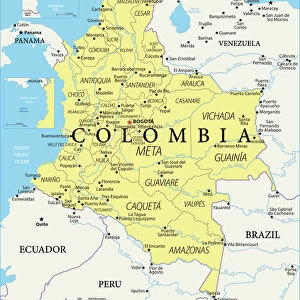
Mouse Mat > South America > Colombia > Maps
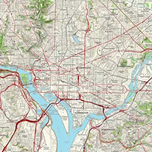
Mouse Mat : Historical city map of Washington D. C. USA, woodcut, published 1897


![]()
Home Decor from Fine Art Storehouse
Historical city map of Washington D. C. USA, woodcut, published 1897
Historical city map of Washington, District of Colombia, capital city of the United States of America. Wood engraving, published in 1897
Unleash your creativity and transform your space into a visual masterpiece!
ZU_09
Media ID 19859993
Mouse Pad
Bring some life into your office, or create a heartfelt gift, with a personalised deluxe Mouse Mat. Made of high-density black foam with a tough, stain-resistant inter-woven cloth cover they will brighten up any home or corporate office.
Archive quality photographic print in a durable wipe clean mouse mat with non slip backing. Works with all computer mice
Estimated Product Size is 24.2cm x 19.7cm (9.5" x 7.8")
These are individually made so all sizes are approximate
Artwork printed orientated as per the preview above, with landscape (horizontal) or portrait (vertical) orientation to match the source image.
FEATURES IN THESE COLLECTIONS
> Fine Art Storehouse
> Map
> Historical Maps
> Fine Art Storehouse
> Map
> USA Maps
> Maps and Charts
> Early Maps
> Maps and Charts
> Related Images
> North America
> United States of America
> Maps
> North America
> United States of America
> Washington, District of Columbia
> North America
> United States of America
> Washington
> Related Images
> South America
> Colombia
> Maps
> South America
> Colombia
> Related Images
EDITORS COMMENTS
This print takes us back in time to the year 1897, offering a glimpse into the historical city map of Washington D. C. , the esteemed capital city of the United States. Crafted with intricate detail using woodcut techniques, this wood engraving showcases the architectural marvels and urban layout that defined Washington's landscape over a century ago. As we explore this vintage depiction, our eyes are drawn to the meticulously etched streets, squares, and landmarks that form the backbone of this iconic metropolis. From Pennsylvania Avenue leading up to the majestic Capitol Building to the grandeur of The White House nestled amidst its surrounding gardens, every element on this map tells a story steeped in history. The artist behind this remarkable piece, ZU_09, has masterfully captured not only the physical geography but also an essence of Washington's rich heritage. It serves as a testament to how cities evolve through time while retaining their unique character. Whether you're an avid historian or simply fascinated by cartography and urban development, this print is sure to transport you back in time and ignite your imagination. Display it proudly on your wall or gift it to someone who appreciates both artistry and American history; either way, it will undoubtedly become a cherished conversation starter for years to come.
MADE IN AUSTRALIA
Safe Shipping with 30 Day Money Back Guarantee
FREE PERSONALISATION*
We are proud to offer a range of customisation features including Personalised Captions, Color Filters and Picture Zoom Tools
SECURE PAYMENTS
We happily accept a wide range of payment options so you can pay for the things you need in the way that is most convenient for you
* Options may vary by product and licensing agreement. Zoomed Pictures can be adjusted in the Cart.