Mouse Mat : The Caucasian Oilfields


![]()
Home Decor from Mary Evans Picture Library
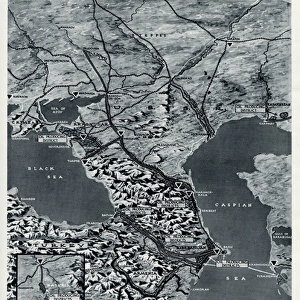
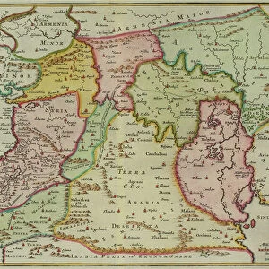
The Caucasian Oilfields
The imminent danger to the pipe-line to Trudovaya by the enemy grip on the Crimea region, the sea of Azov, and Rostov-On-Don.
1941
Mary Evans Picture Library makes available wonderful images created for people to enjoy over the centuries
Media ID 14112045
© Illustrated London News Ltd/Mary Evans
1941 Caucasian Crimea Danger Davis Enemy Grip Illustrating Imminent Oilfields Pictorial Pipe Region Rostov Azov
Mouse Pad
Bring some life into your office, or create a heartfelt gift, with a personalised deluxe Mouse Mat. Made of high-density black foam with a tough, stain-resistant inter-woven cloth cover they will brighten up any home or corporate office.
Archive quality photographic print in a durable wipe clean mouse mat with non slip backing. Works with all computer mice
Estimated Product Size is 19.7cm x 24.2cm (7.8" x 9.5")
These are individually made so all sizes are approximate
Artwork printed orientated as per the preview above, with landscape (horizontal) or portrait (vertical) orientation to match the source image.
EDITORS COMMENTS
This evocative image from the Illustrated London News, published in 1941, depicts the Caucasian Oilfields and the imminent danger they faced during World War II. The map-like illustration highlights the strategic importance of the region, with the pipeline to Trudovaya prominently featured. The pipeline, which transported crude oil from the Caucasus to Rostov-on-Don and further to the Western Front, was a vital supply line for the Soviet Union's war effort. However, the region was under threat as the enemy, referred to in the caption as the "enemy grip on the Crimea region," had seized control of the Crimean Peninsula and the Sea of Azov. The loss of these territories cut off the Soviet Union's access to the Black Sea, making the pipeline even more crucial for the transportation of oil from the Caucasus. The illustration also shows the city of Rostov-on-Don, which was a major industrial center and transportation hub, located at the Don River. The city was under siege by the German forces, and its capture would have significant consequences for the Soviet Union's ability to supply its troops and keep the war effort going. The ominous title of the illustration, "The Caucasian Oilfields: The Imminent Danger to the Pipeline to Trudovaya," underscores the urgency of the situation and the importance of holding onto the region and its vital resources. The image serves as a powerful reminder of the strategic significance of the Caucasian Oilfields during World War II and the efforts to protect them from the enemy's grasp.
MADE IN AUSTRALIA
Safe Shipping with 30 Day Money Back Guarantee
FREE PERSONALISATION*
We are proud to offer a range of customisation features including Personalised Captions, Color Filters and Picture Zoom Tools
SECURE PAYMENTS
We happily accept a wide range of payment options so you can pay for the things you need in the way that is most convenient for you
* Options may vary by product and licensing agreement. Zoomed Pictures can be adjusted in the Cart.