Mouse Mat > Africa > South Africa > Maps
Mouse Mat : Kruger, Joubert and Cronje with map of South Africa


![]()
Home Decor from Mary Evans Picture Library
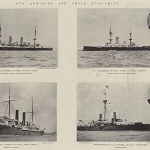
Kruger, Joubert and Cronje with map of South Africa
President Paul Kruger, General Piet Joubert and General Piet Cronje with a map of the Transvaal, South Africa. Date: circa 1900
Mary Evans Picture Library makes available wonderful images created for people to enjoy over the centuries
Media ID 14370192
© Mary Evans / Pharcide
Bloemfontein Boer Boers Joubert Kimberley Kruger Ladysmith Mafeking Maps Piet Pretoria Southern Transvaal Cronje
Mouse Pad
Bring some life into your office, or create a heartfelt gift, with a personalised deluxe Mouse Mat. Made of high-density black foam with a tough, stain-resistant inter-woven cloth cover they will brighten up any home or corporate office.
Archive quality photographic print in a durable wipe clean mouse mat with non slip backing. Works with all computer mice
Estimated Product Size is 24.2cm x 19.7cm (9.5" x 7.8")
These are individually made so all sizes are approximate
Artwork printed orientated as per the preview above, with landscape (horizontal) or portrait (vertical) orientation to match the source image.
FEATURES IN THESE COLLECTIONS
> Africa
> Related Images
> Africa
> South Africa
> Maps
> Africa
> South Africa
> Pretoria
> Africa
> South Africa
> Related Images
> Maps and Charts
> Related Images
EDITORS COMMENTS
This photograph captures a historic moment in South African history, featuring the prominent figures of President Paul Kruger, General Piet Joubert, and General Piet Cronje gathered around a map of the Transvaal Republic in South Africa, circa 1900. At the time, the Second Boer War was raging between the British and the Boer forces, with key battles taking place in Mafeking, Bloemfontein, Ladysmith, and Kimberley. Kruger, the charismatic and determined President of the Transvaal Republic, led the Boer resistance against the British invasion. He was a man of the people, known for his strong leadership and commitment to the Boer cause. To his left, General Piet Joubert, a highly respected military commander, plotted their next moves against the British forces. Joubert's military tactics and strategic mind were instrumental in the early successes of the Boer resistance. On the right, General Piet Cronje, another esteemed military leader, studied the map intently, planning their defensive strategies. Cronje's surrender at Paardeberg in February 1900 marked a turning point in the war, but his leadership and bravery were undeniable. The map spread out before them shows the Transvaal region, highlighting the key locations of the ongoing conflict. The three men, united in their determination to protect their homeland, studied the map, strategized, and prepared for the battles to come. This photograph is a poignant reminder of the courage and resilience of the Boer leaders during a pivotal moment in South African history.
MADE IN AUSTRALIA
Safe Shipping with 30 Day Money Back Guarantee
FREE PERSONALISATION*
We are proud to offer a range of customisation features including Personalised Captions, Color Filters and Picture Zoom Tools
SECURE PAYMENTS
We happily accept a wide range of payment options so you can pay for the things you need in the way that is most convenient for you
* Options may vary by product and licensing agreement. Zoomed Pictures can be adjusted in the Cart.