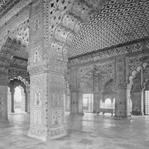
Mouse Mat : Map: Capt Lawrences Military Plan of Delhi


![]()
Home Decor from Mary Evans Picture Library
Map: Capt Lawrences Military Plan of Delhi
Map: Capt Lawrences Military Plan of Delhi and its Contonments from the un-published plans of the Hon E I Company, 1860 (c) (?). Associated with the Indian Mutiny (1857-1859). Date: circa 1860
Mary Evans Picture Library makes available wonderful images created for people to enjoy over the centuries
Media ID 14402603
© The National Army Museum / Mary Evans Picture Library
1857 1859 1860 Associated Capt Delhi Mutiny Plan Plans Lawrences
Mouse Pad
Bring some life into your office, or create a heartfelt gift, with a personalised deluxe Mouse Mat. Made of high-density black foam with a tough, stain-resistant inter-woven cloth cover they will brighten up any home or corporate office.
Archive quality photographic print in a durable wipe clean mouse mat with non slip backing. Works with all computer mice
Estimated Product Size is 24.2cm x 19.7cm (9.5" x 7.8")
These are individually made so all sizes are approximate
Artwork printed orientated as per the preview above, with landscape (horizontal) or portrait (vertical) orientation to match the source image.
EDITORS COMMENTS
This intriguing map, titled "Captain Lawrences Military Plan of Delhi and its Cantonments," offers a fascinating glimpse into the strategic planning of the British military during the Indian Mutiny of 1857-1859. The map, which is believed to have been created circa 1860, was likely derived from unpublished plans of the Honorable East India Company. Captain Lawrences, an officer in the British Army, meticulously detailed the fortifications and defensive positions surrounding Delhi, the historic city that served as the capital of the Mughal Empire until 1857. The map highlights the various cantonments, or military camps, established by the British to secure their control of the region following the outbreak of the Indian Mutiny. The Indian Mutiny, also known as the Sepoy Mutiny, was a widespread uprising against the British East India Company's rule in India. The rebellion began in Meerut in May 1857 and quickly spread to other parts of the country, including Delhi. The British response was swift and decisive, with troops from across the empire being sent to quell the rebellion. This map provides valuable insight into the military strategy employed by the British during this tumultuous period in Indian history. The intricate details of the fortifications and cantonments suggest that the British were taking no chances in securing their hold on Delhi and the surrounding areas. The map also underscores the importance of military planning and the role it played in maintaining colonial rule in Asia during the 19th century. Despite its historical significance, this map remains relatively unknown outside of academic circles. It is a testament to the rich and complex history of India and the British Empire, and serves as a reminder of the strategic importance of military planning in shaping the course of history.
MADE IN AUSTRALIA
Safe Shipping with 30 Day Money Back Guarantee
FREE PERSONALISATION*
We are proud to offer a range of customisation features including Personalised Captions, Color Filters and Picture Zoom Tools
SECURE PAYMENTS
We happily accept a wide range of payment options so you can pay for the things you need in the way that is most convenient for you
* Options may vary by product and licensing agreement. Zoomed Pictures can be adjusted in the Cart.