Mouse Mat > Animals > Mammals > Cricetidae > California Mouse
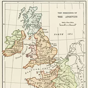
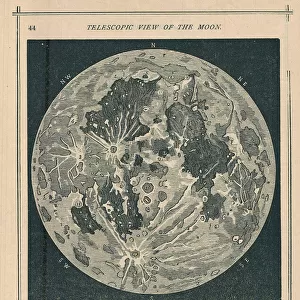
Mouse Mat : California under Mexican rule, 1800s


![]()
Home Decor from North Wind
California under Mexican rule, 1800s
Map of Alta California under Mexican government, early 1800s.
Hand-colored woodcut of a 19th-century illustration
North Wind Picture Archives brings history to life with stock images and hand-colored illustrations
Media ID 5882707
© North Wind Picture Archives
California Colonial Colonist Colony Mexican Mexico West Western Alta California Hispanic
Mouse Pad
Bring some life into your office, or create a heartfelt gift, with a personalised deluxe Mouse Mat. Made of high-density black foam with a tough, stain-resistant inter-woven cloth cover they will brighten up any home or corporate office.
Archive quality photographic print in a durable wipe clean mouse mat with non slip backing. Works with all computer mice
Estimated Product Size is 19.7cm x 24.2cm (7.8" x 9.5")
These are individually made so all sizes are approximate
Artwork printed orientated as per the preview above, with landscape (horizontal) or portrait (vertical) orientation to match the source image.
FEATURES IN THESE COLLECTIONS
> Animals
> Mammals
> Cricetidae
> California Mouse
> Animals
> Mammals
> Muridae
> Western Mouse
> Historic
> Colonial America illustrations
> Colonial America
> Historic
> Colonial America illustrations
> Historic
> Colonial history
> Colonial art and artists
> Maps and Charts
> Early Maps
> North America
> Mexico
> Maps
> North America
> Mexico
> Related Images
> North Wind Picture Archives
> Maps
EDITORS COMMENTS
This beautifully hand-colored woodcut print showcases a historic map of Alta California during the early 1800s, when it was under Mexican rule. The intricate details and vibrant colors bring to life this significant period in American history. The map depicts the vast expanse of California as a Mexican colony, highlighting its importance as a strategic territory for both Mexico and the United States. It serves as a visual representation of the colonial era, reminding us of the complex dynamics between nations during this time. The illustration captures the essence of traditional art from that era, with its meticulous craftsmanship and attention to detail. It transports us back to an age where cartography played a crucial role in understanding and exploring new territories. As we delve into this vintage piece, we are reminded of California's rich Hispanic heritage and its deep-rooted connection to Mexico. This snapshot from history sheds light on how different cultures have shaped North America over centuries. This image is not just an artistic masterpiece but also an educational tool that allows us to appreciate our shared past. It invites us to reflect on the historical significance of colonization while celebrating the diverse tapestry that makes up modern-day California.
MADE IN AUSTRALIA
Safe Shipping with 30 Day Money Back Guarantee
FREE PERSONALISATION*
We are proud to offer a range of customisation features including Personalised Captions, Color Filters and Picture Zoom Tools
SECURE PAYMENTS
We happily accept a wide range of payment options so you can pay for the things you need in the way that is most convenient for you
* Options may vary by product and licensing agreement. Zoomed Pictures can be adjusted in the Cart.