
Mouse Mat > Sheffield City Archives > Maps and Plans
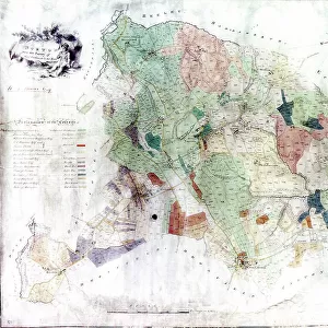
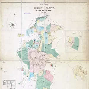
Mouse Mat : Plan of certain surplus freehold land and buildings of the Corporation of Sheffield as allotted for sale, 1854


![]()
Home Decor from Sheffield City Archives
Plan of certain surplus freehold land and buildings of the Corporation of Sheffield as allotted for sale, 1854
Scale 1 inch : 3 chains.S. F. Holmes and S. Worth, Surveyors.R. King, Lithographer, Sheffield.Full details of each lot are given in the sale particulars.Original at Sheffield Local Studies Library: Sale Plans 12 December 1854
Sheffield City Archives and Local Studies Library has an unrivalled collection of images of Sheffield, England
Media ID 14050742
© Sheffield City Council
Anglican Bridge Castle Centre Churches City George Green Hill Hotels House Houses Lane Maps Mill Mills Plans Power Public River Rivers Snig Spring Street Waingate Water West Wheel Alma Bower Bowling Corporation Cotton Dragon Gibraltar Kelvin Newhall Nursery Philips Plum Russell Workhouse
Mouse Pad
Bring some life into your office, or create a heartfelt gift, with a personalised deluxe Mouse Mat. Made of high-density black foam with a tough, stain-resistant inter-woven cloth cover they will brighten up any home or corporate office.
Archive quality photographic print in a durable wipe clean mouse mat with non slip backing. Works with all computer mice
Estimated Product Size is 24.2cm x 19.7cm (9.5" x 7.8")
These are individually made so all sizes are approximate
Artwork printed orientated as per the preview above, with landscape (horizontal) or portrait (vertical) orientation to match the source image.
EDITORS COMMENTS
This print showcases the detailed plan of surplus freehold land and buildings in Sheffield, as allocated for sale in 1854. The scale of this map is 1 inch to 3 chains, providing an accurate representation of the city center and its surrounding areas. Created by S. F. Holmes and S. Worth, surveyors, with lithography by R. King in Sheffield, this historical document offers a glimpse into the city's urban development during that time. The plan highlights various landmarks and districts within Sheffield, including Shalesmoor Street, Gibraltar Bowling Green, Alma Kelham Nursery Bridge, Corporation Cotton Mill Row, Russell Bower Spring Water West Bar Steelhouse Lane Workhouse Love Plum Steam Snig Hill Coulston Newhall Castle Waingate St Philip's Kelvin Anglican Churches Mills Power Union Wheel River Don Rivers George Dragon Public House Houses Hotels. Stored at the Sheffield Local Studies Library under Sale Plans on December 12th, 1854; it provides valuable information about each lot available for purchase during that period. This archival piece not only serves as a record of past land distribution but also sheds light on the growth and evolution of Sheffield over time
MADE IN AUSTRALIA
Safe Shipping with 30 Day Money Back Guarantee
FREE PERSONALISATION*
We are proud to offer a range of customisation features including Personalised Captions, Color Filters and Picture Zoom Tools
SECURE PAYMENTS
We happily accept a wide range of payment options so you can pay for the things you need in the way that is most convenient for you
* Options may vary by product and licensing agreement. Zoomed Pictures can be adjusted in the Cart.

![The Duke of Norfolks estates in Brightside Bierlow, Sheffield, [mid 19th cent]](/sq/716/duke-norfolks-estates-brightside-bierlow-20355002.jpg.webp)
![Sheffield Victoria Station Track layout Plan [N. D]](/sq/229/sheffield-victoria-station-track-layout-plan-n-11762935.jpg.webp)