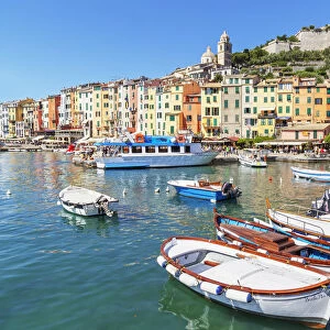
Mouse Mat > Europe > Italy > Heritage Sites > Portovenere, Cinque Terre
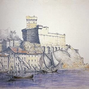
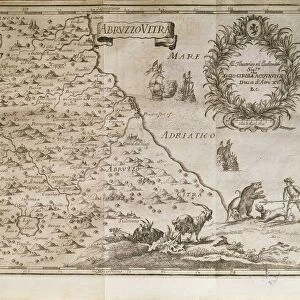
Mouse Mat : Portovenere and the Gulf of La Spezia, Map by Henry Michelot and Laurens Bremond from the Portolan Charts of the Mediterranean Sea, Amsterdam, Copper engraving, 1709


![]()
Home Decor from Universal Images Group (UIG)
Portovenere and the Gulf of La Spezia, Map by Henry Michelot and Laurens Bremond from the Portolan Charts of the Mediterranean Sea, Amsterdam, Copper engraving, 1709
Cartography, Italy, 18th century. Portovenere and the Gulf of La Spezia. Map by Henry Michelot and Laurens Bremond from the Portolan Charts of the Mediterranean Sea, Amsterdam 1709. Copper engraving
Universal Images Group (UIG) manages distribution for many leading specialist agencies worldwide
Media ID 9501991
© DEA PICTURE LIBRARY
18th Century Portovenere Gulf Of La Spezia
Mouse Pad
Bring some life into your office, or create a heartfelt gift, with a personalised deluxe Mouse Mat. Made of high-density black foam with a tough, stain-resistant inter-woven cloth cover they will brighten up any home or corporate office.
Archive quality photographic print in a durable wipe clean mouse mat with non slip backing. Works with all computer mice
Estimated Product Size is 24.2cm x 19.7cm (9.5" x 7.8")
These are individually made so all sizes are approximate
Artwork printed orientated as per the preview above, with landscape (horizontal) or portrait (vertical) orientation to match the source image.
FEATURES IN THESE COLLECTIONS
> Europe
> Italy
> Heritage Sites
> Portovenere, Cinque Terre
> Europe
> Italy
> Liguria
> La Spezia
> Europe
> Italy
> Related Images
> Maps and Charts
> Italy
> Maps and Charts
> Related Images
> Universal Images Group (UIG)
> Art
> Painting, Sculpture & Prints
> Cartography
EDITORS COMMENTS
This print showcases a remarkable piece of cartographic history - the map of Portovenere and the Gulf of La Spezia. Created by Henry Michelot and Laurens Bremond in 1709, this copper engraving is part of the renowned Portolan Charts collection, which meticulously mapped the Mediterranean Sea. The intricate details and exquisite craftsmanship of this 18th-century antique engraving are truly awe-inspiring. The horizontal format allows us to fully appreciate the beauty and complexity of this historical masterpiece. With its precise lines and delicate shading, it transports us back in time to an era when maps were not just navigational tools but works of art. Portovenere, a picturesque Italian village nestled on the Ligurian coast, takes center stage in this map. Its charming streets wind their way through colorful buildings that overlook crystal-clear waters. The Gulf of La Spezia stretches out before us, inviting exploration with its hidden coves and enchanting islands. As we gaze upon this illustration and painting devoid of people, we can't help but marvel at how much has changed since 1709 while also appreciating how some things remain timeless. This image serves as a testament to human curiosity and our eternal quest for knowledge about our surroundings. Let us cherish this extraordinary glimpse into Italy's past - a true treasure from Universal Images Group (UIG).
MADE IN AUSTRALIA
Safe Shipping with 30 Day Money Back Guarantee
FREE PERSONALISATION*
We are proud to offer a range of customisation features including Personalised Captions, Color Filters and Picture Zoom Tools
SECURE PAYMENTS
We happily accept a wide range of payment options so you can pay for the things you need in the way that is most convenient for you
* Options may vary by product and licensing agreement. Zoomed Pictures can be adjusted in the Cart.