
Maps Collection
Maps of Barbados North America are detailed maps that provide a comprehensive overview of the island nation
Choose a picture from our Maps Collection for your Wall Art and Photo Gifts
35 items


All Professionally Made to Order for Quick Shipping
-
Maps Collection
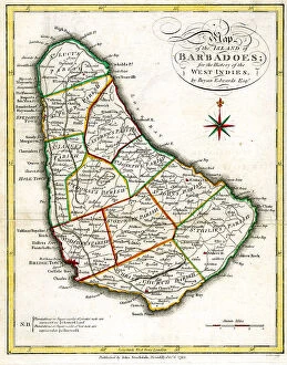
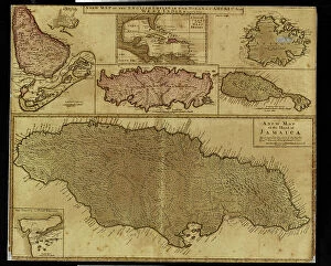
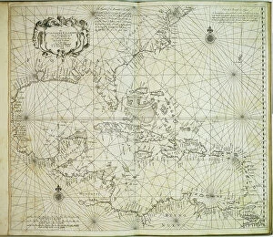
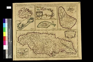
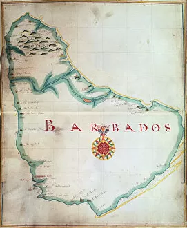
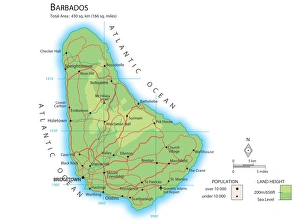
Maps of Barbados North America are detailed maps that provide a comprehensive overview of the island nation. They include physical features such as rivers, mountains, and beaches as well as political boundaries and major cities. they also show points of interest including museums, historical sites, national parks, and other attractions and can be used to plan trips or to gain an understanding of the geography and culture of Barbados. Additionally, they can be used for research purposes or simply to appreciate the beauty of this Caribbean paradise. Maps of Barbados North America are available in both print and digital formats so they can easily be accessed by anyone who wishes to explore this beautiful country.
+
Our beautiful pictures are available as Framed Prints, Photos, Wall Art and Photo Gifts
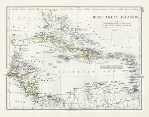
The Maps of Barbados North America collection from Media Storehouse is a unique and fascinating collection of vintage maps that depict the island nation of Barbados. Our collection features a variety of maps, including detailed topographical maps, historical maps dating back to the 17th century, and colorful tourist maps highlighting popular attractions and landmarks. These high-quality prints are available in a range of sizes and formats, including framed prints and canvas wall art. Each map in our collection offers a glimpse into the history and geography of Barbados, showcasing its natural beauty, cultural heritage, and economic development over time. Whether you're an avid collector or simply looking for a beautiful piece of wall art to adorn your home space, the Maps of Barbados North America collection from Media Storehouse is sure to impress. With its stunning imagery and rich historical context, our collection is truly one-of-a-kind.
+
What are Maps of Barbados North America art prints?
Maps of Barbados North America art prints are high-quality reproductions of vintage and contemporary maps depicting the island nation of Barbados. These prints showcase the intricate details, topography, and landmarks that make up this beautiful Caribbean destination. They are perfect for anyone interested in history, geography or travel. These art prints come in a variety of sizes and styles to suit any decor. Some feature vibrant colors while others have a more subdued palette. The maps themselves vary from detailed street plans to broader views showing the entire island. Whether you're looking for a unique gift or simply want to add some visual interest to your home or office, Maps of Barbados North America art prints are an excellent choice. With their timeless appeal and rich historical significance, they will be enjoyed by generations to come.
+
What Maps of Barbados North America art prints can I buy from Media Storehouse?
We offer a wide range of Barbados North America art prints that you can purchase. These maps are available in various sizes and styles, including vintage, contemporary, and artistic designs. You can choose from different types of maps such as topographical, political, physical or satellite imagery. Some popular options include the detailed map of Barbados showing its parishes and towns with their names clearly marked out. Another option is the historical map depicting the island during colonial times when it was under British rule. For those who prefer a more artistic approach to cartography, there are several abstract maps that showcase the beauty of Barbados through vibrant colors and intricate patterns. Whether you're looking for a decorative piece for your home or office or an educational tool for your classroom or library collection, we have something to suit your needs.
+
How do I buy Maps of Barbados North America art prints?
To buy Maps of Barbados North America art prints from Media Storehouse, you can visit their online store and browse through the collection. You can use the search bar to look for specific maps or filter your search by size, orientation, and color. Once you have found a print that you like, click on it to view more details such as the artist's name and printing options. You can choose between different paper types such as photographic paper or fine art paper. You may also select framing options if desired. After selecting your preferences, add the print to your cart and proceed to checkout. At checkout, enter your shipping information and payment details. Review your order summary before submitting it for processing. Your Maps of Barbados North America art print will be printed on high-quality materials using state-of-the-art technology before being shipped directly to you. We offer a wide range of beautiful artwork that is perfect for decorating any space in your home or office.
+
How much do Maps of Barbados North America art prints cost?
The cost of Maps of Barbados North America art prints can vary depending on the size and type of print chosen. There are a variety of options available, including framed or unframed prints, canvas prints, and poster prints. The price range for these options can differ significantly based on the specific product selected. Generally speaking, larger sized maps tend to be more expensive than smaller ones due to the increased materials required for printing and framing. Additionally, certain types of prints such as canvas or poster may come with different pricing structures compared to traditional framed art pieces. It is important to note that while prices may vary between products and retailers, purchasing an art print from Media Storehouse ensures high-quality reproductions at competitive prices. Whether you're looking for a classic map design or something more contemporary in style, there's sure to be a Maps of Barbados North America art print that fits your budget and aesthetic preferences.
+
How will my Maps of Barbados North America art prints be delivered to me?
Your Maps of Barbados North America art prints will be delivered to you securely and efficiently by our trusted delivery partners. We take great care in packaging your artwork to ensure it arrives in pristine condition, using sturdy cardboard tubes or flat packages depending on the size and format of your print. Our team works closely with our delivery partners to provide a seamless experience for our customers, ensuring that your order is tracked every step of the way until it reaches its final destination. We understand how important it is for you to receive your artwork promptly, which is why we strive to dispatch all orders as quickly as possible. Once dispatched, you will receive an email confirmation along with tracking information so that you can monitor the progress of your shipment. Whether you are ordering from within North America or internationally, we aim to deliver your Maps of Barbados art prints safely and swiftly straight to your door.