
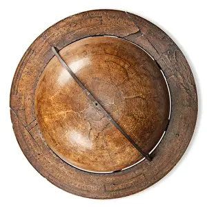
Maps Framed Print Collection (#2)
Discover the breathtaking beauty of Greenland and North America with our Maps of Greenland, North America collection from Media Storehouse. These exquisitely detailed framed prints showcase the stunning topography and geography of the region, from the icy expanse of the Arctic Circle to the vast forests and rugged mountains. Each map is meticulously crafted to bring a sense of wonder and exploration to your home or office. Add these captivating pieces to your decor and transport yourself on a journey across the land of the midnight sun.
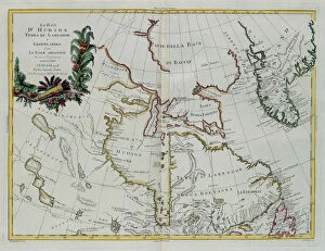
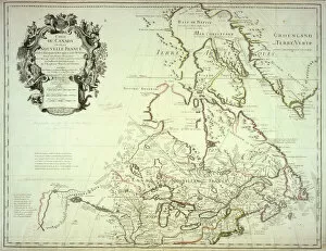
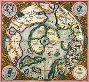
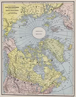
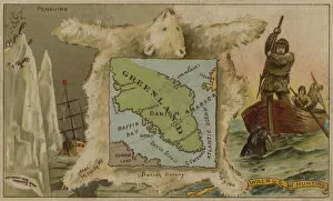
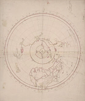
Maps of Greenland North America are a collection that show the physical features of Greenland, a large island located between the Arctic and Atlantic Oceans
212 Framed Prints


All Professionally Made to Order for Quick Shipping
-
Maps Framed Print Collection
Maps of Greenland North America are a collection that show the physical features of Greenland, a large island located between the Arctic and Atlantic Oceans. The maps provide detailed information on the terrain, topography, rivers, lakes and other geographical features. They also include political boundaries such as provinces and townships. Our collection includes both historical and modern maps which can be used for research or recreational purposes. These they are help people to better understand how this remote region has changed over time or to plan trips in the area. Furthermore, they can be used to compare different areas of Greenland with each other or with other parts of North America.
+
Our beautiful Wall Art and Photo Gifts include Framed Prints, Photo Prints, Poster Prints, Canvas Prints, Jigsaw Puzzles, Metal Prints and so much more
The Maps of Greenland North America collection from Media Storehouse is a stunning assortment of wall art and framed prints that showcase the beauty and history of these regions. Our collection features an array of maps, ranging from vintage to contemporary, depicting the topography, geography, and political boundaries of Greenland and North America. The intricate details in each map provide a fascinating insight into the evolution of these regions over time. These maps are perfect for anyone who loves geography or wants to add a touch of sophistication to their home decor. They are available in various sizes and framing options to suit different preferences. Whether you're looking for a unique gift idea or want to adorn your walls with something meaningful, our collection has something for everyone. The Maps of Greenland North America collection is an excellent choice for those seeking high-quality wall art that combines historical significance with aesthetic appeal.
+
What are Maps of Greenland North America art prints?
Maps of Greenland North America art prints are high-quality reproductions of antique maps that depict the regions of Greenland and North America. These maps were originally created by skilled cartographers who meticulously documented the geography, topography, and landmarks of these areas. The Maps of Greenland North America art prints showcase the intricate details and artistic elements that make these vintage maps so unique. These art prints are perfect for anyone interested in history, geography, or cartography. They can be used to decorate homes, offices, classrooms or any space where a touch of sophistication is desired. Additionally, they make great gifts for those who appreciate fine art or have an interest in exploring new places. The Maps of Greenland North America art prints come in various sizes and styles to suit different preferences and decor themes. They are printed on high-quality paper using state-of-the-art printing technology to ensure their longevity and vibrancy over time. These art prints offer a beautiful way to bring history into your home or workspace while adding a touch of elegance to your surroundings.
+
What Maps of Greenland North America art prints can I buy from Media Storehouse?
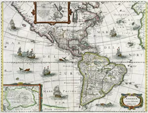
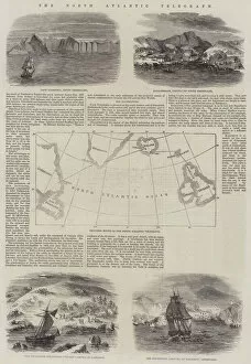
We offer a wide selection of Maps of Greenland and North America art prints that are perfect for home or office decoration. You can choose from vintage maps, satellite images, topographical maps, and more. These art prints come in various sizes to suit your needs and preferences. One popular option is the antique map of North America by John Speed, which showcases the continent's geography in intricate detail. Another great choice is the NASA satellite image of Greenland that captures its stunning glaciers and ice sheets. If you're looking for something unique, Media Storehouse also has a collection of artistic interpretations of these regions' maps. For instance, there's an abstract map print that features bold colors and shapes inspired by the Arctic landscape. Whether you prefer classic or contemporary styles, we have plenty of Maps of Greenland North America art prints to choose from to add character to any space.
+
How do I buy Maps of Greenland North America art prints?
To buy Maps of Greenland North America art prints from Media Storehouse, you can browse our extensive collection of maps and select the one that catches your eye. Once you have found the map print you want to purchase, simply add it to your cart and proceed to checkout. You will be prompted to enter your shipping information and payment details. We offer a variety of sizes for their art prints, so make sure to choose the size that best fits your needs. We also offer framing options for an additional cost if you prefer a ready-to-hang piece. When purchasing art prints from Media Storehouse, rest assured that they use high-quality materials and printing techniques to ensure that each print is vibrant and long-lasting. Whether you are looking for a vintage or modern map of Greenland or North America, we have something for everyone's taste.
+
How much do Maps of Greenland North America art prints cost?
The cost of Maps of Greenland North America art prints varies depending on the size and type of print. We offer a wide range of options, including framed and unframed prints, canvas prints, and posters. The price also depends on whether you choose a vintage or contemporary map design. Generally speaking, smaller sizes such as A4 or 12x16 inches tend to be less expensive than larger sizes like 24x36 inches. However, some collectors may prefer the larger sizes for display purposes. It's worth noting that the quality of the print can also affect the price. Higher-quality paper or printing techniques may result in a higher cost. Ultimately, it's best to browse through our selection to find a map print that fits your budget and preferences. With so many options available, there is sure to be something for everyone at varying price points.
+
How will my Maps of Greenland North America art prints be delivered to me?
Your Maps of Greenland North America art prints will be delivered to you in a safe and secure manner by Media Storehouse. The company takes great care in packaging your artwork so that it arrives at your doorstep undamaged. Your prints will be rolled up and placed inside a sturdy tube for protection during transit. Media Storehouse uses reliable shipping carriers to ensure timely delivery of your order. You can expect to receive regular updates on the status of your shipment, including tracking information once it has been dispatched. Upon receiving your package, carefully remove the prints from the tube and unroll them gently. It is recommended that you allow them to lay flat for a few hours before framing or displaying them. Media Storehouse strives to provide excellent customer service and high-quality products, ensuring that you are completely satisfied with your purchase experience.