
Maps Collection
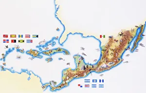
Guatemala is a country located in Central America, bordered by Mexico to the north and west, Belize and the Caribbean Sea to the east
Choose a picture from our Maps Collection for your Wall Art and Photo Gifts
29 items


All Professionally Made to Order for Quick Shipping
-
Maps Collection
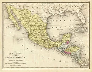
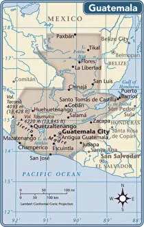
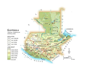
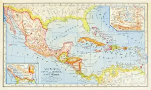
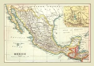
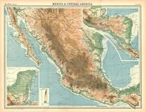
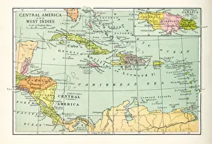
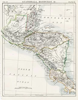
Guatemala is a country located in Central America, bordered by Mexico to the north and west, Belize and the Caribbean Sea to the east, and Honduras and El Salvador to the south and has an area of 108,890 square kilometers (42,043 square miles). Guatemala is divided into 22 departments or states. The capital city is Guatemala City. The terrain of Guatemala consists of mountains in the south and west, with lowlands in between them. The climate ranges from tropical rainforest in the lowlands to temperate forest on higher elevations. Guatemala has a rich cultural heritage that includes Mayan ruins such as Tikal National Park which was declared a World Heritage Site by UNESCO in 1979. Other attractions include colonial cities such as Antigua Guatemala; Lake Atitlan; Semuc Champey Natural Monument; Quetzaltenango; Coban; Chichicastenango; Flores Island on Lake Peten Itza; Rio Dulce National Park; Volcan Pacaya National Park and many more places of interest for tourists visiting this beautiful country.
+
Our beautiful pictures are available as Framed Prints, Photos, Wall Art and Photo Gifts
The Maps of Guatemala North America collection from Media Storehouse is a stunning assortment of wall art and framed prints that depict the geography, topography, and history of Guatemala. Our collection features an array of maps that showcase the country's diverse landscapes, including its mountains, rivers, lakes, and forests. The maps also highlight important landmarks such as ancient ruins and modern cities. Each print in our collection is carefully crafted to provide an accurate representation of Guatemala's unique terrain. The vibrant colors and intricate details make these prints ideal for adding a touch of sophistication to any room or office space. Whether you're a history buff or simply appreciate beautiful artwork, the Maps of Guatemala North America collection has something for everyone. These high-quality prints are perfect for anyone looking to add some cultural flair to their home or workspace while celebrating one of Central America's most fascinating countries.
+
What are Maps of Guatemala North America art prints?
Maps of Guatemala North America art prints are high-quality reproductions of vintage and contemporary maps that depict the geography, topography, and political boundaries of Guatemala and North America. These prints showcase intricate details such as rivers, mountains, cities, towns, roads, and landmarks that make them both informative and visually appealing. These art prints are perfect for those who have an interest in history or geography or want to add a touch of sophistication to their home decor. They come in various sizes and can be framed according to personal preferences. Whether you're looking for a unique gift idea or simply want to decorate your living space with something meaningful and beautiful, Maps of Guatemala North America art prints offer endless possibilities. With their timeless appeal and versatility, they are sure to impress anyone who sees them while providing valuable insights into the past and present landscapes of these regions.
+
What Maps of Guatemala North America art prints can I buy from Media Storehouse?
We offer a wide range of Maps of Guatemala North America art prints that you can purchase. These prints are perfect for those who want to add a touch of sophistication and elegance to their home or office decor. The maps come in various sizes, so you can choose the one that best fits your space. Some of the popular Maps of Guatemala North America art prints available at Media Storehouse include vintage maps, topographical maps, political maps, and satellite imagery. You can also find artistic renditions of these maps that feature vibrant colors and intricate details. Whether you're looking for a map to hang in your living room or office space, we have something for everyone. Our collection is constantly updated with new designs and styles, so you'll always have access to the latest trends in map art prints. If you're looking for high-quality Maps of Guatemala North America art prints that are both beautiful and functional, look no further than Media Storehouse.
+
How do I buy Maps of Guatemala North America art prints?
To buy Maps of Guatemala North America art prints from Media Storehouse, you can follow a few simple steps. Firstly, visit the website and search for 'Maps of Guatemala North America' in the search bar. This will bring up a range of options to choose from. Once you have found the print that you like, select the size and format that suits your needs. Next, add it to your cart and proceed to checkout. You will be prompted to enter your shipping information and payment details at this stage. Ensure that all details are correct before submitting your order. Once your order has been processed, you will receive confirmation via email or text message. Your print will then be shipped out to you within the specified timeframe. It is important to note that these prints are for personal use only and cannot be used commercially without permission from Media Storehouse or the artist who created them.
+
How much do Maps of Guatemala North America art prints cost?
Maps of Guatemala North America art prints are available for purchase at Media Storehouse. The cost of these prints varies depending on the size, material, and framing options chosen by the buyer. You can choose from a range of sizes to suit their needs and budget. The prices may also vary based on whether the print is a reproduction or an original work. We offer high-quality art prints that are perfect for decorating homes or offices. These maps showcase the beauty and intricacies of Guatemala's geography, making them ideal gifts for anyone who loves travel or history. The cost of Maps of Guatemala North America art prints is reasonable considering their quality and uniqueness. They make excellent additions to any collection, whether you're an avid collector or just starting out. With so many options available at Media Storehouse, it's easy to find a map that fits your style and budget without breaking the bank.
+
How will my Maps of Guatemala North America art prints be delivered to me?
Your Maps of Guatemala North America art prints will be delivered to you through a reliable and secure shipping service. The company takes great care in packaging your order to ensure that it arrives at your doorstep in perfect condition. Your print will be carefully rolled and placed inside a sturdy tube, which is then sealed with protective tape. The delivery process is efficient and hassle-free, allowing you to track the progress of your shipment online. You can expect timely updates on the status of your order, including confirmation when it has been dispatched from our warehouse. Upon receiving your package, we recommend unrolling the print immediately and laying it flat for a few hours before framing or hanging. This will help prevent any curling or creasing that may have occurred during transit. You can trust that Media Storehouse will deliver your Maps of Guatemala North America art prints with utmost care and professionalism.