Home > North Wind Picture Archives > Maps
EVNT2A-00019

![]()
Wall Art and Photo Gifts from North Wind
EVNT2A-00019
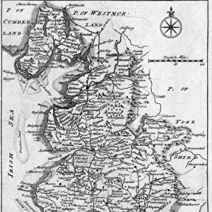
Map showing British colonies and northern New France during the French and Indian War, 1750s.
Printed color lithograph of a 19th century illustration
North Wind Picture Archives brings history to life with stock images and hand-colored illustrations
Media ID 5881909
© North Wind Picture Archives
1700s 1750s 18th Century Atlantic Coast British Canada Colonial Colony Conflict East Eastern Fort French And Indian War French Canada Great Lakes New France Quebec Settlement Territory Seven Years War
EDITORS COMMENTS
This vintage print showcases a captivating map titled "EVNT2A-00019: Map showing British colonies and northern New France during the French and Indian War, 1750s". The intricate details of this 19th-century lithograph provide us with a glimpse into the historical context of North America's colonial past. The vibrant colors bring to life the territorial struggle between the British colonies and French Canada during the mid-18th century. As we explore this illustration, we can see how these two powers vied for control over vast expanses of land along the eastern coast, extending westward towards the Great Lakes region. Notably, Fort Quebec stands prominently on this map as a symbol of French strength in North America. It serves as a reminder of the fierce conflicts that took place during what is known as both the French and Indian War and Seven Years' War. This artwork transports us back to an era when European powers sought dominance over strategic territories across continents. Through its depiction of settlement patterns, it offers valuable insights into early colonial history in North America. As we admire this piece, let us appreciate its artistic value while also acknowledging its significance in understanding our shared heritage.
MADE IN AUSTRALIA
Safe Shipping with 30 Day Money Back Guarantee
FREE PERSONALISATION*
We are proud to offer a range of customisation features including Personalised Captions, Color Filters and Picture Zoom Tools
SECURE PAYMENTS
We happily accept a wide range of payment options so you can pay for the things you need in the way that is most convenient for you
* Options may vary by product and licensing agreement. Zoomed Pictures can be adjusted in the Cart.