Photo Mug > Arts > Artists > H > Joris Hoefnagel
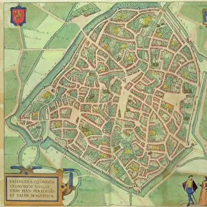
Photo Mug : Map of Valencia, from Civitates Orbis Terrarum


![]()
Home Decor from Fine Art Finder
Map of Valencia, from Civitates Orbis Terrarum
STC138966 Map of Valencia, from Civitates Orbis Terrarum by Georg Braun (1541-1622) and Frans Hogenberg (1535-90) c.1572-1617 (coloured engraving) by Hoefnagel, Joris (1542-1600) (after); Private Collection; The Stapleton Collection; Flemish, out of copyright
Media ID 22352486
© The Stapleton Collection / Bridgeman Images
Atlas Birds Eye View Cities Of The World Crest Moat Moated
Photo Mug
Bring the rich history of Valencia to your morning routine with our Media Storehouse Photo Mug featuring a stunning, vintage map of the city from Civitates Orbis Terrarum. This exquisite engraving, created by Georg Braun and Frans Hogenberg in the late 16th century, showcases the intricate details of Valencia's urban layout during that era. Each mug is expertly printed with high-quality, vibrant colors, ensuring your map remains clear and beautiful even after numerous uses. Start your day with a cup of your favorite beverage and a journey back in time with our Photo Mug – the perfect blend of history and functionality.
A personalised photo mug blends sentimentality with functionality, making an ideal gift for cherished loved ones, close friends, or valued colleagues. Preview may show both sides of the same mug.
Elevate your coffee or tea experience with our premium white ceramic mug. Its wide, comfortable handle makes drinking easy, and you can rely on it to be both microwave and dishwasher safe. Sold in single units, preview may show both sides of the same mug so you can see how the picture wraps around.
Mug Size is 8.1cm high x 9.6cm diameter (3.2" x 3.8")
These are individually made so all sizes are approximate
FEATURES IN THESE COLLECTIONS
> Fine Art Finder
> Artists
> Joris (after) Hoefnagel
> Fine Art Finder
> Maps (celestial & Terrestrial)
> Arts
> Artists
> H
> Joris Hoefnagel
> Europe
> Spain
> Related Images
> Maps and Charts
> Related Images
> Maps and Charts
> Spain
> Maps and Charts
> World
EDITORS COMMENTS
This print showcases a mesmerizing "Map of Valencia" from the renowned Civitates Orbis Terrarum, created by Georg Braun and Frans Hogenberg in the late 16th century. Crafted as a colored engraving by Joris Hoefnagel, this piece offers an exquisite birds-eye view of the Spanish city. The map portrays Valencia's rich history and grandeur with its intricate details and stunning artistry. The city's coat of arms proudly adorns the top corner, symbolizing its heritage and significance. A moat surrounds the city, adding an element of mystique to its fortified walls. As we delve into this masterpiece, we are transported back in time to witness the splendor of Valencia during that era. Every street, building, and landmark is meticulously illustrated, allowing us to explore every nook and cranny of this remarkable metropolis. This print not only serves as a historical document but also as a work of art that captures our imagination. It invites us to immerse ourselves in the vibrant streets teeming with life and marvel at the architectural wonders that have stood for centuries. Whether you are an avid historian or simply appreciate fine craftsmanship, this Map of Valencia will undoubtedly captivate your senses. Its beauty lies not only in its accuracy but also in its ability to transport us through time and space – reminding us of the enduring allure held within these ancient cities across our world.
MADE IN AUSTRALIA
Safe Shipping with 30 Day Money Back Guarantee
FREE PERSONALISATION*
We are proud to offer a range of customisation features including Personalised Captions, Color Filters and Picture Zoom Tools
SECURE PAYMENTS
We happily accept a wide range of payment options so you can pay for the things you need in the way that is most convenient for you
* Options may vary by product and licensing agreement. Zoomed Pictures can be adjusted in the Cart.