Photo Mug > Arts > Artists > P > Portuguese School
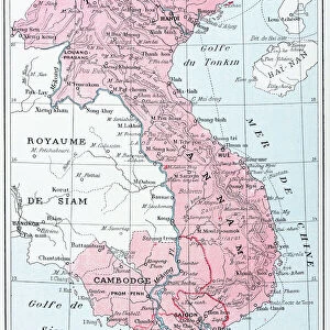
Photo Mug : Map of Spain and France 1869


![]()
Home Decor from Fine Art Storehouse
Map of Spain and France 1869
Cornells Grammars-School Geography - S.S. Cornell - New York D. Appleton and Company 1869
Unleash your creativity and transform your space into a visual masterpiece!
THEPALMER
Media ID 13668859
© Roberto A Sanchez
62990 Earth Globe Man Made Object Globe Navigational Equipment Portugal Obsolete Retro Styled
Photo Mug
Introducing the Media Storehouse Photo Mug featuring the captivating "Map of Spain and France 1869" by THEPALMER from the Fine Art Storehouse. A perfect blend of history and functionality, this mug showcases an intricately detailed map of Spain and France as it appeared in the 1869 edition of Cornell's Geography textbook. Each sip brings you closer to the rich historical context of this classic map, making every moment a journey through time. Embrace the past while enjoying your favorite beverage in this unique and thought-provoking mug.
A personalised photo mug blends sentimentality with functionality, making an ideal gift for cherished loved ones, close friends, or valued colleagues. Preview may show both sides of the same mug.
Elevate your coffee or tea experience with our premium white ceramic mug. Its wide, comfortable handle makes drinking easy, and you can rely on it to be both microwave and dishwasher safe. Sold in single units, preview may show both sides of the same mug so you can see how the picture wraps around.
Mug Size is 9.6cm high x 8.1cm diameter (3.8" x 3.2")
These are individually made so all sizes are approximate
FEATURES IN THESE COLLECTIONS
> Fine Art Storehouse
> The Magical World of Illustration
> Palmer Illustrated Collection
> Fine Art Storehouse
> Map
> Historical Maps
> Arts
> Artists
> P
> Portuguese School
> Arts
> Artists
> S
> Spanish School
> Europe
> Portugal
> Related Images
> Europe
> Related Images
> Europe
> Spain
> Related Images
EDITORS COMMENTS
This print showcases a vintage map of Spain and France from the year 1869. The intricate details and retro styling of this antique piece take us back in time to an era when cartography was meticulously engraved by hand. This particular image is sourced from "Cornells Grammars-School Geography" a renowned publication by S. S. Cornell, published in New York by D. Appleton and Company. The map itself offers a fascinating glimpse into the past, depicting the physical geography of Spain, Portugal, and France during that period. Its old-world charm evokes feelings of nostalgia as we observe the delicate engravings that bring these countries to life on paper. As we examine this engraving closely, we can appreciate how it represents not only an artistic creation but also a valuable navigational tool used at the time. The globe man-made object featured within adds another layer of intrigue to this composition. "The Map of Spain and France 1869" is more than just an obsolete relic; it serves as a testament to human curiosity about our world's landscapes throughout history. With its vertical orientation and detailed illustration, this print invites us to explore Europe's rich tapestry through both geographical knowledge and artistic appreciation. THEPALMER has skillfully captured this timeless piece with precision, allowing viewers to immerse themselves in its historical significance while admiring its aesthetic beauty.
MADE IN AUSTRALIA
Safe Shipping with 30 Day Money Back Guarantee
FREE PERSONALISATION*
We are proud to offer a range of customisation features including Personalised Captions, Color Filters and Picture Zoom Tools
SECURE PAYMENTS
We happily accept a wide range of payment options so you can pay for the things you need in the way that is most convenient for you
* Options may vary by product and licensing agreement. Zoomed Pictures can be adjusted in the Cart.