Photo Mug > North America > Canada > Maps
Photo Mug : Antique Map of the Siege of Louisbourg - 18th Century


![]()
Home Decor from Fine Art Storehouse
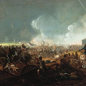
Antique Map of the Siege of Louisbourg - 18th Century
Vintage map of the Siege of Louisbourg in Nova Scotia, Canada. Vintage etching circa late 19th century
Unleash your creativity and transform your space into a visual masterpiece!
powerofforever
Media ID 15149737
© This content is subject to copyright
Territory French And Indian War
Photo Mug
Add a touch of history to your daily routine with our Media Storehouse Antique Map Photo Mug. Featuring an intricately detailed etching of the Antique Map of the Siege of Louisbourg from the Fine Art Storehouse, this mug transports you back in time to the 18th century. Each mug is printed with high-quality, vibrant colors that bring the vintage map to life. Perfect for tea or coffee, this unique mug makes a thoughtful gift for history enthusiasts or anyone who appreciates the beauty of fine art. Embrace the past, one sip at a time.
A personalised photo mug blends sentimentality with functionality, making an ideal gift for cherished loved ones, close friends, or valued colleagues. Preview may show both sides of the same mug.
Elevate your coffee or tea experience with our premium white ceramic mug. Its wide, comfortable handle makes drinking easy, and you can rely on it to be both microwave and dishwasher safe. Sold in single units, preview may show both sides of the same mug so you can see how the picture wraps around.
Mug Size is 8.1cm high x 9.6cm diameter (3.2" x 3.8")
These are individually made so all sizes are approximate
FEATURES IN THESE COLLECTIONS
> Fine Art Storehouse
> Map
> Historical Maps
> Maps and Charts
> Related Images
> North America
> Canada
> Maps
> North America
> Canada
> Related Images
EDITORS COMMENTS
This antique print takes us back in time to the 18th century, specifically to the Siege of Louisbourg in Nova Scotia, Canada. A true vintage gem, this etching from the late 19th century beautifully captures the historical significance and intricate details of this pivotal event. The map showcases Gabarus Bay and its surroundings with remarkable precision, offering a glimpse into a bygone era. The Siege of Louisbourg was a crucial battle during the French and Indian War, where British forces successfully captured the fortified town from French control. This antique map serves as an invaluable historical artifact, providing insight into military strategies and territorial boundaries of that era. The craftsmanship evident in this print is truly remarkable; every line meticulously etched onto paper tells a story of exploration and conquest. As we gaze upon it today, we are reminded of how far we have come while appreciating our rich heritage. Powerofforever's expertise shines through once again with their ability to curate such exceptional pieces for art enthusiasts worldwide. Their dedication to preserving history through fine art prints is commendable. Whether you're an avid collector or simply appreciate the beauty found within historical maps, this Antique Map of the Siege of Louisbourg will undoubtedly transport you back in time. It serves as both a stunning decorative piece for your home or office space and an educational tool that sparks curiosity about our past.
MADE IN AUSTRALIA
Safe Shipping with 30 Day Money Back Guarantee
FREE PERSONALISATION*
We are proud to offer a range of customisation features including Personalised Captions, Color Filters and Picture Zoom Tools
SECURE PAYMENTS
We happily accept a wide range of payment options so you can pay for the things you need in the way that is most convenient for you
* Options may vary by product and licensing agreement. Zoomed Pictures can be adjusted in the Cart.