Photo Mug > North America > United States of America > New York > New York > Maps
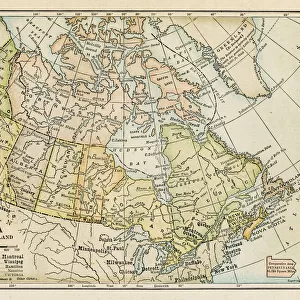
Photo Mug : Map of Canada 1878


![]()
Home Decor from Fine Art Storehouse
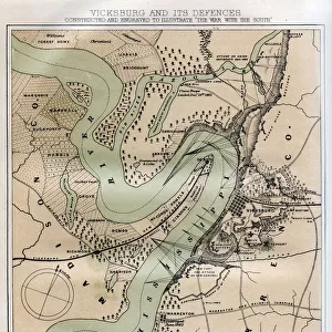
Map of Canada 1878
Encyclopedia Britannica 9th Edition Vol II New York, Samuel Hall 1878
Unleash your creativity and transform your space into a visual masterpiece!
THEPALMER
Media ID 13609291
© This content is subject to copyright
Photo Mug
"Add a touch of history to your daily routine with our Media Storehouse Photo Mugs featuring the captivating "Map of Canada 1878" by THEPALMER from the Fine Art Storehouse. This classic map, originally published in the 9th Edition of Encyclopedia Britannica in New York in 1878, showcases intricate detail and historical accuracy. Each mug holds your favorite beverage while transporting you back in time, making it an excellent gift for history enthusiasts or anyone who appreciates the beauty of vintage maps. Embrace the past, one sip at a time."
A personalised photo mug blends sentimentality with functionality, making an ideal gift for cherished loved ones, close friends, or valued colleagues. Preview may show both sides of the same mug.
Elevate your coffee or tea experience with our premium white ceramic mug. Its wide, comfortable handle makes drinking easy, and you can rely on it to be both microwave and dishwasher safe. Sold in single units, preview may show both sides of the same mug so you can see how the picture wraps around.
Mug Size is 8.1cm high x 9.6cm diameter (3.2" x 3.8")
These are individually made so all sizes are approximate
FEATURES IN THESE COLLECTIONS
> Fine Art Storehouse
> Map
> Historical Maps
> Maps and Charts
> Related Images
> North America
> Canada
> Maps
> North America
> Canada
> Related Images
> North America
> Related Images
> North America
> United States of America
> Maps
> North America
> United States of America
> New York
> New York
> Maps
> North America
> United States of America
> New York
> Related Images
EDITORS COMMENTS
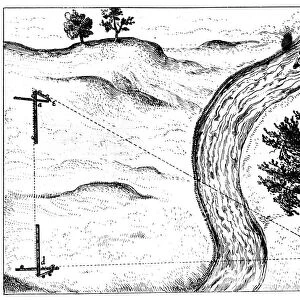
In this print titled "Map of Canada 1878" we are transported back in time to the late 19th century, where cartography was a meticulous art form. This particular piece is sourced from the Encyclopedia Britannica's 9th Edition Volume II, published in New York by Samuel Hall in 1878. The map itself is an exquisite example of engraving and etching techniques, showcasing the intricate details that were painstakingly crafted by skilled artisans. As we gaze upon it, we can't help but marvel at its beauty and historical significance. This antique lithograph offers us a glimpse into Canada's past, revealing not only its geographical features but also providing insight into the country's physical geography during that era. The borders of Canada stretch across the image horizontally while neighboring regions such as the United States and North America are also depicted. As collectors or enthusiasts of old maps would appreciate, this print holds immense value beyond its aesthetic appeal. It serves as a visual testament to how our understanding of geography has evolved over time and reminds us of the importance placed on accurately documenting our world. "The Map of Canada 1878" by THEPALMER invites us to explore history through artistry—a timeless reminder that even within seemingly mundane objects like maps lies a wealth of knowledge waiting to be discovered.
MADE IN AUSTRALIA
Safe Shipping with 30 Day Money Back Guarantee
FREE PERSONALISATION*
We are proud to offer a range of customisation features including Personalised Captions, Color Filters and Picture Zoom Tools
SECURE PAYMENTS
We happily accept a wide range of payment options so you can pay for the things you need in the way that is most convenient for you
* Options may vary by product and licensing agreement. Zoomed Pictures can be adjusted in the Cart.