Photo Mug > North America > United States of America > New York > New York > Maps
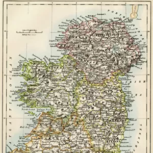
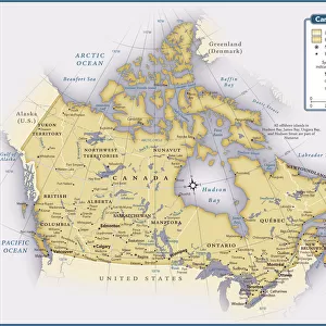
Photo Mug : Map of Canada 1895


![]()
Home Decor from Fine Art Storehouse
Map of Canada 1895
The Rand-McNally Grammar School Geography 1895 - Chicago & New York
Unleash your creativity and transform your space into a visual masterpiece!
THEPALMER
Media ID 14824603
© This content is subject to copyright
Alberta British British Columbia North America Nova Scotia Ontario Quebec Manitoba New Brunswick Saskatchewan
Photo Mug
Add a touch of history to your morning routine with our Media Storehouse Photo Mug featuring the stunning "Map of Canada 1895" by THEPALMER from the Fine Art Storehouse. This vintage map, taken from the Rand-McNally Grammar School Geography 1895, is now available in mug form for you to enjoy your favorite beverage. Each mug is expertly printed with high-quality images to ensure vibrant and long-lasting designs. Perfect for history enthusiasts, geography buffs, or anyone who appreciates the beauty of old maps, this mug makes a unique and thoughtful gift. Embrace the past while staying cozy and caffeinated with a Media Storehouse Photo Mug.
A personalised photo mug blends sentimentality with functionality, making an ideal gift for cherished loved ones, close friends, or valued colleagues. Preview may show both sides of the same mug.
Elevate your coffee or tea experience with our premium white ceramic mug. Its wide, comfortable handle makes drinking easy, and you can rely on it to be both microwave and dishwasher safe. Sold in single units, preview may show both sides of the same mug so you can see how the picture wraps around.
Mug Size is 8.1cm high x 9.6cm diameter (3.2" x 3.8")
These are individually made so all sizes are approximate
FEATURES IN THESE COLLECTIONS
> Fine Art Storehouse
> Map
> Historical Maps
> Maps and Charts
> Related Images
> North America
> Canada
> Maps
> North America
> Canada
> Related Images
> North America
> Related Images
> North America
> United States of America
> New York
> New York
> Maps
> North America
> United States of America
> New York
> Related Images
EDITORS COMMENTS
This print showcases a historical gem, the "Map of Canada 1895" sourced from "The Rand-McNally Grammar School Geography 1895" publication in Chicago and New York. Brought to life by THEPALMER, this piece takes us on a visual journey through the Canadian provinces and territories as they were over a century ago. With meticulous detail and artistic precision, this map beautifully captures the vastness of Canada's landscape. From Alberta to British Columbia, Manitoba to Newfoundland, each region is intricately outlined with names that evoke nostalgia for a bygone era. The inclusion of Nova Scotia, Ontario, Quebec, Saskatchewan, and other significant areas further enriches our understanding of Canada's diverse geography. This print transports us back in time when cartography was an art form unto itself. It serves as a reminder of how maps have been instrumental in shaping our perception of the world throughout history. As we gaze upon this vintage treasure meticulously reproduced by THEPALMER for Fine Art Storehouse, we are reminded not only of its aesthetic appeal but also its educational value. Whether you are an avid collector or simply appreciate historical artifacts like this one-of-a-kind map print depicting early Canadian geography, it is sure to spark curiosity and ignite conversations about our nation's past. Let it adorn your walls as both an exquisite decorative piece and a testament to the rich heritage that has shaped modern-day Canada.
MADE IN AUSTRALIA
Safe Shipping with 30 Day Money Back Guarantee
FREE PERSONALISATION*
We are proud to offer a range of customisation features including Personalised Captions, Color Filters and Picture Zoom Tools
SECURE PAYMENTS
We happily accept a wide range of payment options so you can pay for the things you need in the way that is most convenient for you
* Options may vary by product and licensing agreement. Zoomed Pictures can be adjusted in the Cart.