Photo Mug > Europe > United Kingdom > Wales > Maps
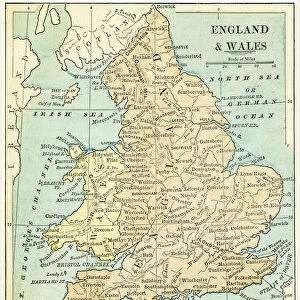
Photo Mug : Map of England and Wales 1900


![]()
Home Decor from Fine Art Storehouse
Map of England and Wales 1900
Meyers hand-Atlas Leipzig und Wien Verlag des Bibliographischen Instituts 1900
Unleash your creativity and transform your space into a visual masterpiece!
THEPALMER
Media ID 18106867
© 2014 Roberto Adrian Photography
Photo Mug
Add a touch of history to your daily routine with our Media Storehouse Photo Mug featuring a vintage map of England and Wales from 1900. This beautiful design is taken from THEPALMER's Map of England and Wales, published by Meyers Hand-Atlas Leipzig und Wien Verlag des Bibliographischen Instituts. Each mug holds your favorite beverage and showcases the intricate details of this historic map, making it a unique and thoughtful gift for history enthusiasts or anyone who appreciates the charm of old maps. Embrace the past with every sip.
A personalised photo mug blends sentimentality with functionality, making an ideal gift for cherished loved ones, close friends, or valued colleagues. Preview may show both sides of the same mug.
Elevate your coffee or tea experience with our premium white ceramic mug. Its wide, comfortable handle makes drinking easy, and you can rely on it to be both microwave and dishwasher safe. Sold in single units, preview may show both sides of the same mug so you can see how the picture wraps around.
Mug Size is 9.6cm high x 8.1cm diameter (3.8" x 3.2")
These are individually made so all sizes are approximate
FEATURES IN THESE COLLECTIONS
> Fine Art Storehouse
> Map
> Historical Maps
> Europe
> United Kingdom
> England
> Maps
> Europe
> United Kingdom
> England
> Posters
> Europe
> United Kingdom
> England
> Related Images
> Europe
> United Kingdom
> Wales
> Maps
> Europe
> United Kingdom
> Wales
> Posters
> Europe
> United Kingdom
> Wales
> Related Images
> Maps and Charts
> Wales
EDITORS COMMENTS
In this photo print, titled "Map of England and Wales 1900". THEPALMER takes us on a nostalgic journey back in time. The image showcases an exquisite piece from the renowned Meyers hand-Atlas Leipzig und Wien Verlag des Bibliographischen Instituts 1900 collection. With its intricate details and vintage charm, this map offers a fascinating glimpse into the past. As we gaze upon this historical artifact, our eyes are immediately drawn to the beautifully illustrated landscapes that span across England and Wales. Every contour, river, and city is meticulously depicted with remarkable precision, showcasing the cartographer's dedication to accuracy. The delicate shading techniques employed add depth and dimension to each region, inviting us to explore every nook and cranny of these ancient lands. Transporting us back over a century ago, this map serves as a time capsule capturing the essence of early 20th-century geography. It evokes feelings of curiosity about how life might have been during that era - bustling cities filled with horse-drawn carriages or quaint villages nestled amidst picturesque countryside. THEPALMER's expertly captured photograph ensures that every minute detail is preserved for generations to come. This stunning print not only appeals to history enthusiasts but also serves as an artistic masterpiece worthy of display in any home or office setting. Immerse yourself in the rich heritage of England and Wales through this extraordinary print – a testament to both THEPALMER's skillful photography and the enduring beauty found within antique maps like those from
MADE IN AUSTRALIA
Safe Shipping with 30 Day Money Back Guarantee
FREE PERSONALISATION*
We are proud to offer a range of customisation features including Personalised Captions, Color Filters and Picture Zoom Tools
SECURE PAYMENTS
We happily accept a wide range of payment options so you can pay for the things you need in the way that is most convenient for you
* Options may vary by product and licensing agreement. Zoomed Pictures can be adjusted in the Cart.