Photo Mug > Europe > Belgium > Maps
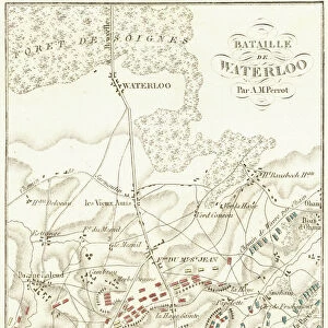
Photo Mug : Map of Hollan and Belgium 1889


![]()
Home Decor from Fine Art Storehouse
Map of Hollan and Belgium 1889
Comprehensive Geography by James Monteith - American Book Company 1882, 1889
Unleash your creativity and transform your space into a visual masterpiece!
THEPALMER
Media ID 18357317
Photo Mug
Bring a piece of history to your morning routine with our Media Storehouse Photo Mug featuring the classic Map of Holland and Belgium by THEPALMER from the Fine Art Storehouse. This detailed map, originally published in Comprehensive Geography by James Monteith in 1889, is now available in mug form for you to enjoy your favorite beverage. Perfect for history enthusiasts, travelers, or anyone who appreciates the beauty of vintage maps, this mug makes a unique and thoughtful gift. Each mug is printed with high-quality, fade-resistant ink, ensuring your map stays vibrant and clear. Embrace the past and start your day with a touch of nostalgia and geography trivia. Order yours today!
A personalised photo mug blends sentimentality with functionality, making an ideal gift for cherished loved ones, close friends, or valued colleagues. Preview may show both sides of the same mug.
Elevate your coffee or tea experience with our premium white ceramic mug. Its wide, comfortable handle makes drinking easy, and you can rely on it to be both microwave and dishwasher safe. Sold in single units, preview may show both sides of the same mug so you can see how the picture wraps around.
Mug Size is 9.6cm high x 8.1cm diameter (3.8" x 3.2")
These are individually made so all sizes are approximate
FEATURES IN THESE COLLECTIONS
> Fine Art Storehouse
> Map
> Historical Maps
> Europe
> Belgium
> Related Images
> Maps and Charts
> Related Images
EDITORS COMMENTS
This print showcases a remarkable piece of history, the "Map of Holland and Belgium 1889". Taken from the pages of James Monteith's renowned book "Comprehensive Geography" published by the American Book Company in 1882 and later updated in 1889, this image offers us a glimpse into the past. The intricate details and exquisite craftsmanship of this map are truly awe-inspiring. As we delve into its depths, we are transported to an era where cartography was both an art form and a scientific endeavor. Every contour, river, city, and border is meticulously depicted with utmost precision. This map serves as a testament to the dedication and expertise required to create such comprehensive geographical representations during that time. The historical significance of this particular edition cannot be overstated. It provides us with invaluable insights into how these countries were perceived over a century ago. Moreover, it allows us to trace their evolution through time - observing changes in boundaries, cities' growth or decline, and even alterations in political affiliations. "The Map of Holland and Belgium 1889" is not just an artifact; it is a window into our collective past. Its presence on display at Fine Art Storehouse reminds us of our enduring fascination with maps as tools for exploration and understanding. Whether you're an avid historian or simply appreciate fine artistry combined with geographic accuracy, this print by THEPALMER will undoubtedly captivate your imagination while offering glimpses into Europe's rich heritage.
MADE IN AUSTRALIA
Safe Shipping with 30 Day Money Back Guarantee
FREE PERSONALISATION*
We are proud to offer a range of customisation features including Personalised Captions, Color Filters and Picture Zoom Tools
SECURE PAYMENTS
We happily accept a wide range of payment options so you can pay for the things you need in the way that is most convenient for you
* Options may vary by product and licensing agreement. Zoomed Pictures can be adjusted in the Cart.