Photo Mug > Europe > France > Canton > Maine
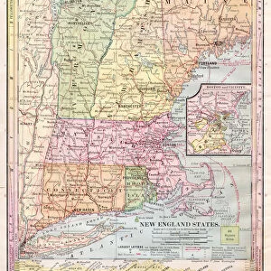
Photo Mug : Map of New England 1877


![]()
Home Decor from Fine Art Storehouse
Map of New England 1877
Warrens Common School Geography 1877
Unleash your creativity and transform your space into a visual masterpiece!
THEPALMER
Media ID 14824547
© This content is subject to copyright
Connecticut Maine Massachusetts New England New Hampshire Rhode Island Vermont
Photo Mug
Add a touch of history to your daily routine with our Media Storehouse Photo Mug featuring the stunning "Map of New England 1877" by THEPALMER from Fine Art Storehouse. This vintage geography map, originally published in Warren's Common School Atlas of 1877, is now brought to life on a high-quality, glossy ceramic mug. Perfect for sipping your favorite beverage while reminiscing about the past or sharing a piece of American history with others. Each mug comes with a clear coating for easy cleaning and is microwave and dishwasher safe. Order now and make every sip an adventure through time! #MapOfNewEngland #VintageMap #HistoricalMug #FineArtMug
A personalised photo mug blends sentimentality with functionality, making an ideal gift for cherished loved ones, close friends, or valued colleagues. Preview may show both sides of the same mug.
Elevate your coffee or tea experience with our premium white ceramic mug. Its wide, comfortable handle makes drinking easy, and you can rely on it to be both microwave and dishwasher safe. Sold in single units, preview may show both sides of the same mug so you can see how the picture wraps around.
Mug Size is 9.6cm high x 8.1cm diameter (3.8" x 3.2")
These are individually made so all sizes are approximate
FEATURES IN THESE COLLECTIONS
> Fine Art Storehouse
> Map
> Historical Maps
> Europe
> France
> Canton
> Maine
> Europe
> United Kingdom
> England
> Hampshire
> Related Images
> Europe
> United Kingdom
> England
> Maps
> Europe
> United Kingdom
> England
> Posters
> Europe
> United Kingdom
> England
> Related Images
> Maps and Charts
> Related Images
EDITORS COMMENTS
This print titled "Map of New England 1877" takes us on a journey back in time to the late 19th century. The map, originally featured in Warrens Common School Geography of 1877, offers a glimpse into the intricate details and artistry that went into cartography during this era. The image showcases the northeastern region of the United States, encompassing Connecticut, New Hampshire, Rhode Island, Vermont, Maine, and Massachusetts. Each state is meticulously outlined with delicate precision and adorned with vibrant colors that bring life to the paper. The map serves as both an educational tool and a work of art. As we examine this historical piece closely, we can appreciate how it captures not only geographical information but also hints at the cultural and societal aspects prevalent during that period. It invites us to ponder upon what life might have been like for those living in these states over a century ago. "The Map of New England 1877" by THEPALMER stands as a testament to human curiosity and exploration. Its presence evokes nostalgia while simultaneously reminding us of our ever-changing world. This print from Fine Art Storehouse allows us to preserve history within our homes or offices—a tangible reminder of where we come from and how far we have progressed since then.
MADE IN AUSTRALIA
Safe Shipping with 30 Day Money Back Guarantee
FREE PERSONALISATION*
We are proud to offer a range of customisation features including Personalised Captions, Color Filters and Picture Zoom Tools
SECURE PAYMENTS
We happily accept a wide range of payment options so you can pay for the things you need in the way that is most convenient for you
* Options may vary by product and licensing agreement. Zoomed Pictures can be adjusted in the Cart.