Photo Mug > Arts > Artists > B > Augustus Butler
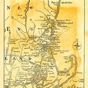
Photo Mug : Map of New England state 1881


![]()
Home Decor from Fine Art Storehouse
Map of New England state 1881
A System of Modern Geography designed for the use of schools and academies by Augustus Mitchell - Published by T. H. Butler / Philadelphia 1881
Unleash your creativity and transform your space into a visual masterpiece!
THEPALMER
Media ID 18357237
Photo Mug
Bring a piece of history to your morning routine with our Media Storehouse Photo Mug featuring a vintage Map of New England from 1881. This beautiful design, sourced from the Fine Art Storehouse, showcases intricate details of the New England region as depicted in "A System of Modern Geography" by Augustus Mitchell, published by T. H. Butler in Philadelphia. Each mug holds your favorite beverage and serves as a unique conversation starter, making it a thoughtful gift for history enthusiasts or anyone who appreciates the beauty of old maps. Embrace the past, one sip at a time.
A personalised photo mug blends sentimentality with functionality, making an ideal gift for cherished loved ones, close friends, or valued colleagues. Preview may show both sides of the same mug.
Elevate your coffee or tea experience with our premium white ceramic mug. Its wide, comfortable handle makes drinking easy, and you can rely on it to be both microwave and dishwasher safe. Sold in single units, preview may show both sides of the same mug so you can see how the picture wraps around.
Mug Size is 9.6cm high x 8.1cm diameter (3.8" x 3.2")
These are individually made so all sizes are approximate
FEATURES IN THESE COLLECTIONS
> Fine Art Storehouse
> Map
> Historical Maps
> Arts
> Artists
> B
> Augustus Butler
> Europe
> United Kingdom
> England
> Maps
> Europe
> United Kingdom
> England
> Posters
> Europe
> United Kingdom
> England
> Related Images
> Maps and Charts
> Related Images
EDITORS COMMENTS
This print showcases a beautifully detailed "Map of New England state 1881" by Augustus Mitchell, published in Philadelphia in the same year. A true testament to the artistry and precision of cartography, this vintage map takes us back to a time when exploration and discovery were at their peak. The intricate details on this map are truly remarkable, depicting the six states that make up New England with utmost accuracy. From the rugged coastlines of Maine to the rolling hills of Vermont, every contour and boundary is meticulously outlined. The vibrant colors used to differentiate each state add an element of visual appeal, making it not only informative but also visually striking. As we gaze upon this historical artifact, we can't help but be transported back to a time when these states were still evolving and shaping their identities. It serves as a reminder of how far we have come since then while honoring our rich heritage. "The Map of New England state 1881" is more than just a geographical representation; it encapsulates an era defined by curiosity and intellectual growth. Whether displayed in classrooms or homes, this print offers both educational value and aesthetic pleasure for those who appreciate history's profound impact on our present-day lives.
MADE IN AUSTRALIA
Safe Shipping with 30 Day Money Back Guarantee
FREE PERSONALISATION*
We are proud to offer a range of customisation features including Personalised Captions, Color Filters and Picture Zoom Tools
SECURE PAYMENTS
We happily accept a wide range of payment options so you can pay for the things you need in the way that is most convenient for you
* Options may vary by product and licensing agreement. Zoomed Pictures can be adjusted in the Cart.