Photo Mug > Maps and Charts > Related Images
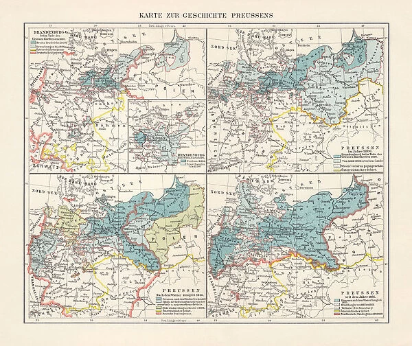
Photo Mug : Map on the territorial development of Prussia, lithograph, 1897
![]()

Home Decor from Fine Art Storehouse
Map on the territorial development of Prussia, lithograph, 1897
Map on the territorial development of Prussia: Top, left) Brandenburg at the death of the Great Elector in 1688; top, right) Prussia in 1806); bottom, left) Prussia after the Congress of Vienna in 1815; bottom, right) Prussia after 1866. Lithograph, published in 1897
Unleash your creativity and transform your space into a visual masterpiece!
ZU_09
Media ID 18292261
Photo Mug
Add a touch of history to your morning routine with our Media Storehouse Photo Mug featuring the intriguing map of Prussia's territorial development, a captivating lithograph from 1897 by ZU_09 from Fine Art Storehouse. This detailed map showcases the expansion of Prussia from Brandenburg at the death of the Great Elector in 1688 to its peak in 1806. Each sip from this high-quality mug brings a piece of history to your day, making it a unique and thoughtful gift for history enthusiasts or anyone who appreciates the beauty of historical cartography.
A personalised photo mug blends sentimentality with functionality, making an ideal gift for cherished loved ones, close friends, or valued colleagues. Preview may show both sides of the same mug.
Elevate your coffee or tea experience with our premium white ceramic mug. Its wide, comfortable handle makes drinking easy, and you can rely on it to be both microwave and dishwasher safe. Sold in single units, preview may show both sides of the same mug so you can see how the picture wraps around.
Mug Size is 8.1cm high x 9.6cm diameter (3.2" x 3.8")
These are individually made so all sizes are approximate
FEATURES IN THESE COLLECTIONS
> Fine Art Storehouse
> Map
> Historical Maps
> Maps and Charts
> Related Images
EDITORS COMMENTS
This lithograph print takes us on a historical journey through the territorial development of Prussia. Dating back to 1897, this remarkable piece showcases four distinct maps that shed light on the evolution of Prussia's boundaries over time. The top left map depicts Brandenburg at the death of the Great Elector in 1688, revealing the extent of Prussian influence during this period. Moving clockwise, we encounter the top right map showcasing Prussia in 1806, capturing a pivotal moment when Napoleon's forces threatened its sovereignty. As our eyes descend to the bottom left corner, we witness Prussia after the Congress of Vienna in 1815. This particular map highlights how diplomatic negotiations reshaped and solidified Prussian territories following years of political upheaval across Europe. Finally, we arrive at the bottom right section where we see Prussia after 1866. Here, we witness further expansion and consolidation as new territories were incorporated into an ever-growing empire. Through ZU_09's expert lithography skills, each intricate detail is brought to life with precision and clarity. The fine lines and delicate shading capture not only geographical changes but also reflect significant moments in history that shaped both Prussian identity and European politics as a whole. This print serves as a valuable educational tool for history enthusiasts or anyone curious about Germany's past. It invites viewers to explore centuries-old transformations while appreciating artistry that stands the test of time.
MADE IN AUSTRALIA
Safe Shipping with 30 Day Money Back Guarantee
FREE PERSONALISATION*
We are proud to offer a range of customisation features including Personalised Captions, Color Filters and Picture Zoom Tools
SECURE PAYMENTS
We happily accept a wide range of payment options so you can pay for the things you need in the way that is most convenient for you
* Options may vary by product and licensing agreement. Zoomed Pictures can be adjusted in the Cart.


