Photo Mug > North America > United States of America > New York > New York > Maps
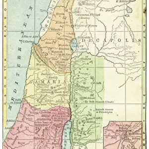
Photo Mug : Palestine map 1885


![]()
Home Decor from Fine Art Storehouse
Palestine map 1885
Encyclopedia Britannica 9th Edition New York Charles Scribners and Sons 1885 Vol XVIII
Unleash your creativity and transform your space into a visual masterpiece!
THEPALMER
Media ID 14756638
© This content is subject to copyright
Photo Mug
Introducing the Media Storehouse Photo Mug, a unique and thoughtful gift that allows you to showcase your favorite images in a functional and stylish way. This mug features a captivating historical image of the Palestine map from the 9th Edition of Encyclopedia Britannica, published by Charles Scribners and Sons in New York in 1885. The intricate details of the map, sourced from THEPALMER's collection at the Fine Art Storehouse, are beautifully displayed on the mug's durable ceramic surface. Each sip from this mug will transport you back in time, making it an ideal gift for history enthusiasts, collectors, or anyone who appreciates the beauty of vintage maps. Embrace the past and make your morning coffee or tea routine a little more interesting with this one-of-a-kind Photo Mug from Media Storehouse.
A personalised photo mug blends sentimentality with functionality, making an ideal gift for cherished loved ones, close friends, or valued colleagues. Preview may show both sides of the same mug.
Elevate your coffee or tea experience with our premium white ceramic mug. Its wide, comfortable handle makes drinking easy, and you can rely on it to be both microwave and dishwasher safe. Sold in single units, preview may show both sides of the same mug so you can see how the picture wraps around.
Mug Size is 9.6cm high x 8.1cm diameter (3.8" x 3.2")
These are individually made so all sizes are approximate
FEATURES IN THESE COLLECTIONS
> Fine Art Storehouse
> Map
> Historical Maps
> Asia
> Palestine
> Related Images
> Maps and Charts
> Related Images
> North America
> United States of America
> New York
> New York
> Maps
> North America
> United States of America
> New York
> Related Images
EDITORS COMMENTS
In this print titled "Palestine map 1885" we are transported back in time to the late 19th century, where we can explore the intricate details of a historical artifact. The image showcases a meticulously crafted map from the Encyclopedia Britannica's 9th Edition, published by Charles Scribners and Sons in New York in 1885. The map itself is a testament to both artistry and cartography, offering us a glimpse into how Palestine was perceived during that era. With its delicate lines and carefully shaded regions, it presents an invaluable resource for understanding the geographical boundaries of Palestine at that specific point in history. As our eyes trace over the contours of this vintage map, we discover familiar names such as Samaria and other notable locations within Palestine. Each detail serves as a reminder of the rich cultural heritage embedded within these lands. "The Palmer" who has brought us this remarkable photographic reproduction through Fine Art Storehouse, allows us to appreciate not only the historical significance but also the artistic beauty found within this piece. Through their lens, they have captured every nuance with precision and care. This print invites us on an exploratory journey through time while reminding us of our collective human history. It serves as a tangible link connecting past generations to present-day conversations surrounding Palestine's complex narrative - one that continues to shape our world today.
MADE IN AUSTRALIA
Safe Shipping with 30 Day Money Back Guarantee
FREE PERSONALISATION*
We are proud to offer a range of customisation features including Personalised Captions, Color Filters and Picture Zoom Tools
SECURE PAYMENTS
We happily accept a wide range of payment options so you can pay for the things you need in the way that is most convenient for you
* Options may vary by product and licensing agreement. Zoomed Pictures can be adjusted in the Cart.