Photo Mug > Europe > United Kingdom > England > Southampton
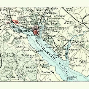
Photo Mug : Southampton England map 1895


![]()
Home Decor from Fine Art Storehouse
Southampton England map 1895
Meyers Konversations-Lexikon. Ein Nachschlagewerk des allgemeinen Wissens, 5th edition 17 volumes Bibliographisches Institut - Leipzig 1895-1897
Unleash your creativity and transform your space into a visual masterpiece!
THEPALMER
Media ID 13609309
© This content is subject to copyright
Harbor Port Southampton England
Photo Mug
"Add a touch of history to your daily routine with our Media Storehouse Photo Mugs. Featuring an exquisite image of a Southampton England map from 1895, taken from the renowned "Meyers Konversations-Lexikon" published by Bibliographisches Institut. This vintage map, sourced from THEPALMER's collection at the Fine Art Storehouse, is now transformed into a functional and stylish mug. Ideal for tea or coffee, this mug not only keeps your beverage warm but also showcases a piece of historical art. Perfect for history enthusiasts or as a thoughtful gift, each mug is printed with high-quality, fade-resistant ink to ensure the image remains vibrant and clear. Enjoy your favorite drink while immersing yourself in the rich history of Southampton."
A personalised photo mug blends sentimentality with functionality, making an ideal gift for cherished loved ones, close friends, or valued colleagues. Preview may show both sides of the same mug.
Elevate your coffee or tea experience with our premium white ceramic mug. Its wide, comfortable handle makes drinking easy, and you can rely on it to be both microwave and dishwasher safe. Sold in single units, preview may show both sides of the same mug so you can see how the picture wraps around.
Mug Size is 8.1cm high x 9.6cm diameter (3.2" x 3.8")
These are individually made so all sizes are approximate
FEATURES IN THESE COLLECTIONS
> Fine Art Storehouse
> Map
> Historical Maps
> Europe
> United Kingdom
> England
> Maps
> Europe
> United Kingdom
> England
> Posters
> Europe
> United Kingdom
> England
> Related Images
> Europe
> United Kingdom
> England
> Southampton
> Maps and Charts
> Related Images
EDITORS COMMENTS
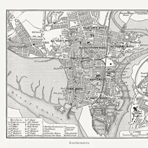
This print showcases a historical map of Southampton, England from the year 1895. The map is sourced from Meyers Konversations-Lexikon, an esteemed encyclopedia published in Leipzig between 1895 and 1897. With its detailed engravings and etchings, this antique illustration provides a fascinating glimpse into the city's past. The map highlights various aspects of Southampton, including its port and harbor, which have played significant roles in shaping the city's identity throughout history. Its horizontal layout allows for easy navigation through the streets and landmarks that were present during that era. As one explores this physical geography depiction, they can immerse themselves in the rich cartography that captures both the beauty and intricacies of Southampton at that time. From bustling city streets to serene coastal areas, this old map offers a comprehensive view of what life was like over a century ago. "ThePalmer" who curated this stunning print available at Fine Art Storehouse, has preserved not only a piece of history but also an artistic representation worth cherishing. Whether you are an enthusiast of vintage maps or simply intrigued by Southampton's heritage, this exquisite print will undoubtedly transport you back in time to experience the charm and allure of this English city as it once was.
MADE IN AUSTRALIA
Safe Shipping with 30 Day Money Back Guarantee
FREE PERSONALISATION*
We are proud to offer a range of customisation features including Personalised Captions, Color Filters and Picture Zoom Tools
SECURE PAYMENTS
We happily accept a wide range of payment options so you can pay for the things you need in the way that is most convenient for you
* Options may vary by product and licensing agreement. Zoomed Pictures can be adjusted in the Cart.