Photo Mug > Historic > Ancient civilizations > Roman Empire > Roman art
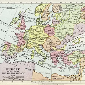
Photo Mug : Map of Germannia, mid-2nd century AD, lithograph, published in 1897


![]()
Home Decor from Fine Art Storehouse
Map of Germannia, mid-2nd century AD, lithograph, published in 1897
Map of Germania and the northern provinces of the Roman Empire around the middle of the 2nd century AD. Lithograph, published in 1897
Unleash your creativity and transform your space into a visual masterpiece!
Media ID 15192942
© This content is subject to copyright
Photo Mug
Step back in time with our Media Storehouse Photo Mug, featuring a captivating historical image of a Map of Germania from the Fine Art Storehouse collection. Published in 1897, this intricately detailed lithograph showcases the northern provinces of the Roman Empire during the mid-2nd century AD. Perfect for history enthusiasts, this mug not only serves your favorite beverage but also adds a touch of ancient wisdom to your daily routine. Embrace the past, one sip at a time.
A personalised photo mug blends sentimentality with functionality, making an ideal gift for cherished loved ones, close friends, or valued colleagues. Preview may show both sides of the same mug.
Elevate your coffee or tea experience with our premium white ceramic mug. Its wide, comfortable handle makes drinking easy, and you can rely on it to be both microwave and dishwasher safe. Sold in single units, preview may show both sides of the same mug so you can see how the picture wraps around.
Mug Size is 8.1cm high x 9.6cm diameter (3.2" x 3.8")
These are individually made so all sizes are approximate
FEATURES IN THESE COLLECTIONS
> Fine Art Storehouse
> Map
> Map Illustrations
> Arts
> Artists
> R
> Roman Roman
> Historic
> Ancient civilizations
> Roman Empire
> Roman art
> Maps and Charts
> Related Images
EDITORS COMMENTS
This lithograph, published in 1897, showcases a remarkable Map of Germannia from the mid-2nd century AD. A true testament to the artistry and precision of cartography, this print offers us a glimpse into the ancient world and its intricate geographical boundaries. The map depicts Germania and the northern provinces of the Roman Empire during a pivotal era in history. With delicate strokes and meticulous detailing, it presents an expansive view of territories that were once governed by Rome. From dense forests to winding rivers, every element is intricately portrayed with utmost accuracy. As we study this lithograph, we are transported back in time to an age where empires clashed and cultures intermingled. It allows us to trace the footsteps of ancient civilizations as they navigated through these lands - their triumphs, struggles, and conquests etched upon each contour. Published over a century ago but still retaining its allure today, this print serves as both an educational tool for historians and a work of art for enthusiasts alike. Its vintage aesthetic adds charm while reminding us of our connection to those who came before us. Whether displayed on museum walls or cherished within personal collections, this Map of Germannia lithograph continues to captivate viewers with its historical significance and artistic brilliance.
MADE IN AUSTRALIA
Safe Shipping with 30 Day Money Back Guarantee
FREE PERSONALISATION*
We are proud to offer a range of customisation features including Personalised Captions, Color Filters and Picture Zoom Tools
SECURE PAYMENTS
We happily accept a wide range of payment options so you can pay for the things you need in the way that is most convenient for you
* Options may vary by product and licensing agreement. Zoomed Pictures can be adjusted in the Cart.