Photo Mug > Maps and Charts > Related Images
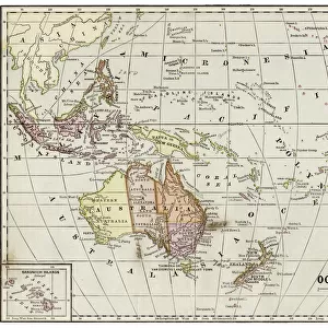
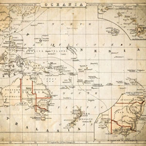
Photo Mug : Map of Oceania 1868


![]()
Home Decor from Fine Art Storehouse
Map of Oceania 1868
Guyots The Earth Common School Geography - 1868
Unleash your creativity and transform your space into a visual masterpiece!
THEPALMER
Media ID 20251073
© A 2014 Roberto Adrian Photography
Photo Mug
Bring a piece of historical cartography to your morning routine with our Media Storehouse Photo Mug featuring the captivating Map of Oceania 1868 by THEPALMER from our Fine Art Storehouse collection. This vintage geography map, taken from Guyot's The Earth Common School Geography - 1868, adds an intriguing touch to your daily coffee or tea. Embrace the rich history of cartography as you enjoy your favorite beverage. Order now and make every sip an adventure in time!
A personalised photo mug blends sentimentality with functionality, making an ideal gift for cherished loved ones, close friends, or valued colleagues. Preview may show both sides of the same mug.
Elevate your coffee or tea experience with our premium white ceramic mug. Its wide, comfortable handle makes drinking easy, and you can rely on it to be both microwave and dishwasher safe. Sold in single units, preview may show both sides of the same mug so you can see how the picture wraps around.
Mug Size is 8.1cm high x 9.6cm diameter (3.2" x 3.8")
These are individually made so all sizes are approximate
FEATURES IN THESE COLLECTIONS
> Maps and Charts
> Related Images
EDITORS COMMENTS
This photo print, titled "Map of Oceania 1868" takes us on a mesmerizing journey back in time. A relic from the past, this piece hails from Guyots The Earth Common School Geography - 1868 and is now brought to life by THEPALMER through Fine Art Storehouse. The map itself is an exquisite depiction of Oceania as it stood in the late 19th century. With intricate details and delicate craftsmanship, it offers a glimpse into the world as explorers once knew it. From Australia's vast expanse to the scattered islands dotting the Pacific Ocean, every corner of this diverse region comes alive with vibrant colors and precise cartographic accuracy. As we delve deeper into this historical gem, we can't help but marvel at its educational significance. This map would have been an invaluable tool for students during its time—a window into distant lands that sparked curiosity and ignited imaginations. It serves as a reminder of how knowledge was disseminated before modern technology took over classrooms. Beyond its academic value, however, lies an undeniable aesthetic appeal. The aged texture adds character to the print while enhancing our appreciation for its vintage charm. Whether displayed in a study or adorning the walls of a history enthusiast's home, this artwork effortlessly transports us back to an era when exploration was paramount. In essence, "Map of Oceania 1868" invites us to embark on a visual voyage through time—an opportunity to rediscover our planet's past while embracing
MADE IN AUSTRALIA
Safe Shipping with 30 Day Money Back Guarantee
FREE PERSONALISATION*
We are proud to offer a range of customisation features including Personalised Captions, Color Filters and Picture Zoom Tools
SECURE PAYMENTS
We happily accept a wide range of payment options so you can pay for the things you need in the way that is most convenient for you
* Options may vary by product and licensing agreement. Zoomed Pictures can be adjusted in the Cart.