Photo Mug > Animals > Mammals > Muridae > Western Mouse
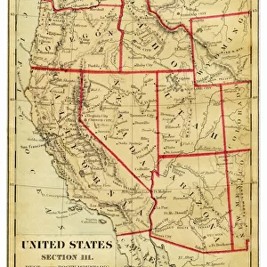
Photo Mug : USA Western states map 1898


![]()
Home Decor from Fine Art Storehouse
USA Western states map 1898
Map from Physical Geography by R. S. Tarr - The MacMillan Company - London 1898
Unleash your creativity and transform your space into a visual masterpiece!
THEPALMER
Media ID 20773173
© A 2014 Roberto Adrian Photography
Photo Mug
"Add a touch of history to your morning routine with our Media Storehouse Photo Mugs featuring the "USA Western States Map 1898" by THEPALMER from Fine Art Storehouse. This vintage map, taken from R.S. Tarr's "Physical Geography" published by The MacMillan Company in 1898, is now available in mug form. Each mug holds your favorite beverage while showcasing the intricate details of the western United States as it was depicted over a century ago. A perfect gift for history enthusiasts, avid collectors, or anyone who appreciates the beauty of classic cartography. Embrace the past, one sip at a time."
A personalised photo mug blends sentimentality with functionality, making an ideal gift for cherished loved ones, close friends, or valued colleagues. Preview may show both sides of the same mug.
Elevate your coffee or tea experience with our premium white ceramic mug. Its wide, comfortable handle makes drinking easy, and you can rely on it to be both microwave and dishwasher safe. Sold in single units, preview may show both sides of the same mug so you can see how the picture wraps around.
Mug Size is 9.6cm high x 8.1cm diameter (3.8" x 3.2")
These are individually made so all sizes are approximate
FEATURES IN THESE COLLECTIONS
> Fine Art Storehouse
> Map
> USA Maps
> Animals
> Mammals
> Muridae
> Western Mouse
> Europe
> United Kingdom
> England
> London
> Related Images
> Maps and Charts
> Related Images
> North America
> United States of America
> Maps
EDITORS COMMENTS
This print takes us back in time to the year 1898, when the vast and unexplored landscapes of the western United States were still a mystery waiting to be unraveled. The map featured in this image is an exquisite piece from "Physical Geography" by R. S. Tarr, published by The MacMillan Company in London. As we gaze upon this vintage treasure, our eyes are drawn to the intricate details that adorn each state within the Western region of America. From California's golden shores to Arizona's arid deserts, and from Oregon's lush forests to Nevada's rugged mountains, every contour and boundary comes alive with historical significance. The craftsmanship captured here transports us into an era where cartography was both artistry and science combined. It reminds us of a time when explorers ventured into these untamed territories armed only with their curiosity and determination. "The Palmer" known for curating exceptional pieces at Fine Art Storehouse, has preserved this remarkable snapshot of history for all enthusiasts to appreciate. This particular print serves as a testament not only to the beauty of early cartographic works but also as a reminder of how far we have come since those pioneering days. Whether you are an avid historian or simply captivated by the allure of yesteryears, this photograph invites you on a journey through time - one that will leave you marveling at the vastness and diversity that define America's Western states even today.
MADE IN AUSTRALIA
Safe Shipping with 30 Day Money Back Guarantee
FREE PERSONALISATION*
We are proud to offer a range of customisation features including Personalised Captions, Color Filters and Picture Zoom Tools
SECURE PAYMENTS
We happily accept a wide range of payment options so you can pay for the things you need in the way that is most convenient for you
* Options may vary by product and licensing agreement. Zoomed Pictures can be adjusted in the Cart.