Photo Mug > Arts > Street art graffiti > Digital art > Digital paintings
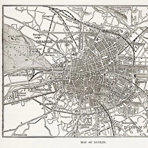
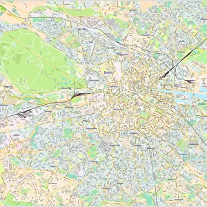
Photo Mug : Mid-nineteenth century map of Dublin, Ireland


![]()
Home Decor from Fine Art Storehouse
Mid-nineteenth century map of Dublin, Ireland
A mid-19th century map of Dublin the capital of the Republic of Ireland which, at the time the engraving was made, was part of Great Britain. From Our Own Country: Descriptive, Historical, Pictoriala published by Cassell & Co Ltd, 1885
Unleash your creativity and transform your space into a visual masterpiece!
whitemay
Media ID 18142963
© Digitally restored by Linda Steward - Linda Steward
Photo Mug
Step back in time with our Media Storehouse Photo Mug featuring a captivating mid-19th century map of Dublin, Ireland. This exquisite design, sourced from the Fine Art Storehouse, showcases the historic layout of the city during the British rule. Perfect for tea or coffee breaks, this high-quality mug not only keeps your beverage warm but also adds a touch of history to your daily routine. Bring a piece of the past into your present with our Photo Mug.
A personalised photo mug blends sentimentality with functionality, making an ideal gift for cherished loved ones, close friends, or valued colleagues. Preview may show both sides of the same mug.
Elevate your coffee or tea experience with our premium white ceramic mug. Its wide, comfortable handle makes drinking easy, and you can rely on it to be both microwave and dishwasher safe. Sold in single units, preview may show both sides of the same mug so you can see how the picture wraps around.
Mug Size is 8.1cm high x 9.6cm diameter (3.2" x 3.8")
These are individually made so all sizes are approximate
FEATURES IN THESE COLLECTIONS
> Fine Art Storehouse
> Map
> Historical Maps
> Fine Art Storehouse
> Travel Imagery
> Travel Destinations
> Ireland
> Dublin, Ireland
> Arts
> Street art graffiti
> Digital art
> Digital paintings
> Europe
> Republic of Ireland
> Dublin
> Europe
> Republic of Ireland
> Maps
> Europe
> Republic of Ireland
> Related Images
> Maps and Charts
> Early Maps
> Maps and Charts
> Related Images
EDITORS COMMENTS
This print showcases a mid-nineteenth century map of Dublin, Ireland, providing us with a glimpse into the city's rich history. At this time, Dublin served as the capital of the Republic of Ireland but was still under British rule. The engraving beautifully captures the intricate details and landmarks that defined the city during this period. The map offers an invaluable historical perspective on Dublin's development and layout in the 1800s. It allows us to trace its bustling streets, admire its architectural wonders, and explore its vibrant neighborhoods. From iconic landmarks like Trinity College and St. Patrick's Cathedral to lesser-known corners such as Donnybrook, every inch of this map tells a story waiting to be discovered. Originally published in 1885 by Cassell & Co Ltd. , as part of their comprehensive work "Our Own Country: Descriptive, Historical, Pictorial" this print is not just a piece of art but also an educational tool for those interested in Irish history or cartography enthusiasts. Whitemay has skillfully preserved this remarkable piece from our past through their expert printing techniques. Whether you are an avid collector or simply seeking to adorn your space with a touch of nostalgia and cultural significance, this print is sure to captivate viewers and spark conversations about Dublin's fascinating heritage.
MADE IN AUSTRALIA
Safe Shipping with 30 Day Money Back Guarantee
FREE PERSONALISATION*
We are proud to offer a range of customisation features including Personalised Captions, Color Filters and Picture Zoom Tools
FREE COLORIZATION SERVICE
You can choose advanced AI Colorization for this picture at no extra charge!
SECURE PAYMENTS
We happily accept a wide range of payment options so you can pay for the things you need in the way that is most convenient for you
* Options may vary by product and licensing agreement. Zoomed Pictures can be adjusted in the Cart.