Photo Mug > Maps and Charts > Related Images
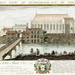
Photo Mug : Old Map of The South Pole originally Published by J. Seller 1684


![]()
Home Decor from MapSeeker
Old Map of The South Pole originally Published by J. Seller 1684
An interesting reproduction from the rare miniature map of the South Polar region, from Sellers Atlas Maritimus. Both the cartographic detail and embellishments are based upon the Hondius/Jansson map of the South Polar regions
Welcome to the Mapseeker Image library and enter an historic gateway to one of the largest on-line collections of Historic Maps, Nostalgic Views, Vista's and Panorama's from a World gone by.
Media ID 20346892
Photo Mug
Discover the captivating history of exploration with our Media Storehouse Photo Mug featuring an old map of the South Pole, originally published by J. Seller in 1684. This intriguing reproduction hails from the rare miniature map of the South Polar region, taken from the Seller's Atlas Maritimus. The exquisite cartographic detail brings the intrigue of early polar exploration right to your hands. Each mug holds your favorite beverage while serving as a fascinating conversation starter. Embrace the allure of the past with this unique and thoughtful addition to your daily routine.
A personalised photo mug blends sentimentality with functionality, making an ideal gift for cherished loved ones, close friends, or valued colleagues. Preview may show both sides of the same mug.
Elevate your coffee or tea experience with our premium white ceramic mug. Its wide, comfortable handle makes drinking easy, and you can rely on it to be both microwave and dishwasher safe. Sold in single units, preview may show both sides of the same mug so you can see how the picture wraps around.
Mug Size is 8.1cm high x 9.6cm diameter (3.2" x 3.8")
These are individually made so all sizes are approximate
EDITORS COMMENTS
This print showcases an extraordinary piece of cartographic history - an old map of the South Pole originally published by J. Seller in 1684. A true gem for any avid map enthusiast, this reproduction offers a glimpse into the past and invites us to explore the uncharted territories of early exploration. Derived from the rare miniature map found within Sellers Atlas Maritimus, this intriguing artwork captures both intricate cartographic details and exquisite embellishments reminiscent of the renowned Hondius/Jansson map of the South Polar regions. It is a testament to the dedication and craftsmanship that went into creating these historical maps. As we gaze upon this remarkable print, our imagination takes flight, envisioning intrepid explorers braving treacherous icy landscapes in search of new discoveries. The delicate lines depict unexplored coastlines and unknown islands waiting to be explored by adventurous souls who dared venture into these remote corners of our planet. Beyond its aesthetic appeal, this photograph holds immense educational value as it allows us to understand how perceptions of our world have evolved over time. It reminds us that once upon a time, vast stretches were shrouded in mystery and intrigue; now they are charted with precision thanks to pioneers like J. Seller. Let this mesmerizing image transport you back centuries ago when brave sailors embarked on perilous journeys across unforgiving seas towards lands yet unseen - a testament to human curiosity and resilience engraved on paper for generations to come.
MADE IN AUSTRALIA
Safe Shipping with 30 Day Money Back Guarantee
FREE PERSONALISATION*
We are proud to offer a range of customisation features including Personalised Captions, Color Filters and Picture Zoom Tools
SECURE PAYMENTS
We happily accept a wide range of payment options so you can pay for the things you need in the way that is most convenient for you
* Options may vary by product and licensing agreement. Zoomed Pictures can be adjusted in the Cart.