Photo Mug > Africa > Egypt > Maps
Photo Mug : Map of the Ancient Persian Empire


![]()
Home Decor from Mary Evans Picture Library
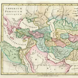
Map of the Ancient Persian Empire
Map of the Ancient Persian Empire, encompassing Greece to the north west, Arabia to the south east, Egypt and Libya to the south west and deep in the Caucasus in the north east. Date: 1798
Mary Evans Picture Library makes available wonderful images created for people to enjoy over the centuries
Media ID 11575329
© Mary Evans / Grenville Collins Postcard Collection
1798 Arabian Caucasus Chart Gulf Maps Mediterranean Persian Persians Scythia Territories Territory
Photo Mug
Introducing the Media Storehouse Photo Mug, featuring an intriguing image of the Ancient Persian Empire from Mary Evans Prints Online. This exquisite map, dated 1798, showcases the vast expanse of the Persian Empire during its golden age, stretching from Greece to the northwest, Arabia to the south east, Egypt and Libya to the southwest, and deep into the Caucasus in the north east. Bring a piece of history into your daily routine as you sip your favorite beverage from this high-quality mug. The vivid print ensures every detail of the map is visible, making it a captivating conversation starter. Order yours today and immerse yourself in the rich history of the ancient world.
A personalised photo mug blends sentimentality with functionality, making an ideal gift for cherished loved ones, close friends, or valued colleagues. Preview may show both sides of the same mug.
Elevate your coffee or tea experience with our premium white ceramic mug. Its wide, comfortable handle makes drinking easy, and you can rely on it to be both microwave and dishwasher safe. Sold in single units, preview may show both sides of the same mug so you can see how the picture wraps around.
Mug Size is 8.1cm high x 9.6cm diameter (3.2" x 3.8")
These are individually made so all sizes are approximate
FEATURES IN THESE COLLECTIONS
> Africa
> Egypt
> Related Images
> Africa
> Libya
> Related Images
> Asia
> India
> Related Images
> Asia
> Turkey
> Related Images
> Europe
> Greece
> Related Images
> Maps and Charts
> Early Maps
> Popular Themes
> Maps and Charts
EDITORS COMMENTS
This stunning map print, created in the late 18th century, offers a captivating glimpse into the vast territories of the Ancient Persian Empire as it existed in 1798. The Persian Empire, ruled by the Persian monarchs, reached its zenith during this period, extending from Greece in the northwest, through modern-day Turkey and the Middle East, to Egypt and Libya in the southwest, deep into the Caucasus in the northeast, and even touching the Indian subcontinent. The map meticulously illustrates the empire's diverse geographical features, including the fertile plains of Mesopotamia, the rugged mountains of the Caucasus, the vast deserts of Arabia, and the shimmering waters of the Gulf Sea. The territories under Persian rule are depicted in rich detail, with cities, rivers, and mountains all clearly marked. The map also highlights the empire's strategic locations, such as the crucial trade routes that connected the Mediterranean world to the Indian subcontinent. The Persian Empire's influence extended far beyond its borders, with the Scythians to the north and India to the east also depicted on the map. This historical map is an invaluable resource for scholars, educators, and anyone interested in the ancient world. It offers a unique perspective on the size and scope of one of history's most powerful empires, and serves as a reminder of the rich cultural heritage that continues to shape our world today.
MADE IN AUSTRALIA
Safe Shipping with 30 Day Money Back Guarantee
FREE PERSONALISATION*
We are proud to offer a range of customisation features including Personalised Captions, Color Filters and Picture Zoom Tools
SECURE PAYMENTS
We happily accept a wide range of payment options so you can pay for the things you need in the way that is most convenient for you
* Options may vary by product and licensing agreement. Zoomed Pictures can be adjusted in the Cart.