Photo Mug > Arts > Artists > S > Syrian Syrian
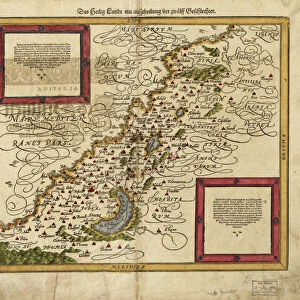
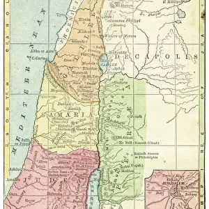
Photo Mug : Map of Palestine and the Holy Land


![]()
Home Decor from Mary Evans Picture Library
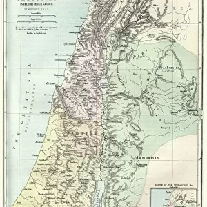
Map of Palestine and the Holy Land
Map of Palestine and the Holy Land - all places named in their Latin form. Date: 1806
Mary Evans Picture Library makes available wonderful images created for people to enjoy over the centuries
Media ID 11575327
© Mary Evans / Grenville Collins Postcard Collection
1806 Chart Damascus Dead Galilee Israel Jerusalem Maps Palestine Palestinian Ports Scale Sidon Syria Syrian Territory Tyre
Photo Mug
Introducing the Media Storehouse Photo Mug, a unique and thoughtful gift that allows you to carry your favorite images with you everywhere you go. This mug features a stunning, historic map of Palestine and the Holy Land, dated 1806. The map, sourced from Mary Evans Prints Online, showcases all the places named in their Latin form, making it a fascinating addition to any collection. Each mug is expertly printed with high-quality, vibrant colors to bring the image to life. Perfect for history buffs, travel enthusiasts, or anyone with a deep appreciation for the rich cultural heritage of the Middle East, this mug is sure to impress and delight. Order yours today and start your day with a dose of history and inspiration.
A personalised photo mug blends sentimentality with functionality, making an ideal gift for cherished loved ones, close friends, or valued colleagues. Preview may show both sides of the same mug.
Elevate your coffee or tea experience with our premium white ceramic mug. Its wide, comfortable handle makes drinking easy, and you can rely on it to be both microwave and dishwasher safe. Sold in single units, preview may show both sides of the same mug so you can see how the picture wraps around.
Mug Size is 9.6cm high x 8.1cm diameter (3.8" x 3.2")
These are individually made so all sizes are approximate
FEATURES IN THESE COLLECTIONS
> Arts
> Artists
> S
> Syrian Syrian
> Asia
> Israel
> Related Images
> Asia
> Palestine
> Jerusalem
> Asia
> Palestine
> Related Images
> Asia
> Syria
> Related Images
EDITORS COMMENTS
This intricately detailed map, titled "Palestina et Terra Sancta" and dated 1806, offers a glimpse into the historical geography of the Middle East, focusing on the region now known as Palestine and the Holy Land. The map, which is adorned with Latin names for various places, was created during a time when European powers were increasing their influence in the region. The map provides a clear representation of the coastal cities, including Tyre, Sidon, and Jaffa, with their ports marked as important points of entry and exit. The Dead Sea, the lowest point on Earth, is also depicted, along with the Syrian border and the bustling city of Damascus. The heart of the map, however, is the region of Galilee and Judea, which includes the ancient city of Jerusalem. The map's key reveals that the scale is set at 1:1,250,000, providing a sense of the vastness of the land. The map serves as an essential historical document, illustrating the complex geography of the region during a time of significant political and cultural change. It offers a window into the past, providing valuable context for understanding the rich history of the Middle East, particularly the Holy Land, and its enduring significance in world history.
MADE IN AUSTRALIA
Safe Shipping with 30 Day Money Back Guarantee
FREE PERSONALISATION*
We are proud to offer a range of customisation features including Personalised Captions, Color Filters and Picture Zoom Tools
SECURE PAYMENTS
We happily accept a wide range of payment options so you can pay for the things you need in the way that is most convenient for you
* Options may vary by product and licensing agreement. Zoomed Pictures can be adjusted in the Cart.