Photo Mug > Europe > United Kingdom > England > London > Transport > Railway
Photo Mug : London railways map


![]()
Home Decor from Mary Evans Picture Library
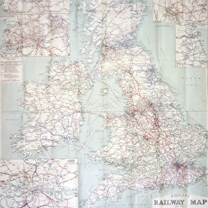
London railways map
City & North East Suburban Electric Railway map, 1903 Date: 1903
Mary Evans Picture Library makes available wonderful images created for people to enjoy over the centuries
Media ID 7401951
© Mary Evans Picture Library 2015 - https://copyrighthub.org/s0/hub1/creation/maryevans/MaryEvansPictureID/10474752
Photo Mug
"Bring a piece of history to your morning routine with our Media Storehouse Photo Mugs. Featuring an iconic London Railways Map from 1903, sourced from Mary Evans Prints Online, these mugs are more than just a beverage holder. Each mug showcases intricate details of the City & North East Suburban Electric Railway, transporting you back in time with every sip. A perfect gift for railway enthusiasts, history buffs, or anyone who appreciates the beauty of vintage maps. Order yours today and start your day with a dose of nostalgia!"
A personalised photo mug blends sentimentality with functionality, making an ideal gift for cherished loved ones, close friends, or valued colleagues. Preview may show both sides of the same mug.
Elevate your coffee or tea experience with our premium white ceramic mug. Its wide, comfortable handle makes drinking easy, and you can rely on it to be both microwave and dishwasher safe. Sold in single units, preview may show both sides of the same mug so you can see how the picture wraps around.
Mug Size is 9.6cm high x 8.1cm diameter (3.8" x 3.2")
These are individually made so all sizes are approximate
FEATURES IN THESE COLLECTIONS
> Mary Evans Prints Online
> National Archives
> Europe
> United Kingdom
> England
> London
> Related Images
> Europe
> United Kingdom
> England
> London
> Transport
> Railway
> Maps and Charts
> Related Images
> Popular Themes
> Railway Posters
EDITORS COMMENTS
1. Title: "A Journey Through Time: London's Electric Railways in 1903" This print showcases the City & North East Suburban Electric Railway map of London, dated 1903. The map, a testament to the evolution of public transportation in the city, offers a glimpse into the past when electric railways began to transform the way Londoners moved around their metropolis. The year 1903 marked a significant milestone in London's transport history, as the electric railway network expanded, providing a more efficient and convenient alternative to the traditional steam-powered trains. This map, produced by an unknown cartographer, illustrates the extensive network of electric lines that crisscrossed the city and its suburbs. The map's intricate details reveal the various railway lines, stations, and connections that served London and its surrounding areas. The City & North East Suburban Electric Railway, also known as the "Northern Line," is prominently displayed, connecting the City of London to the northern suburbs. Other lines, such as the Edgware Road & Hampstead Railway and the Central London Railway (later known as the Central Line), are also shown, highlighting the extensive reach of the electric railway network. The map's design is both functional and aesthetically pleasing, with a clear and easy-to-read layout that would have been invaluable to travelers in the early 1900s. The use of color-coding to distinguish different lines and the inclusion of key landmarks and points of interest add to the map's charm and historical significance. This print serves as a fascinating reminder of London's rich transport history and the role electric railways played in shaping the city's urban landscape. It invites us to explore the past and appreciate the progress that has been made in public transportation over the past century.
MADE IN AUSTRALIA
Safe Shipping with 30 Day Money Back Guarantee
FREE PERSONALISATION*
We are proud to offer a range of customisation features including Personalised Captions, Color Filters and Picture Zoom Tools
SECURE PAYMENTS
We happily accept a wide range of payment options so you can pay for the things you need in the way that is most convenient for you
* Options may vary by product and licensing agreement. Zoomed Pictures can be adjusted in the Cart.