Photo Mug > Arts > Landscape paintings > Waterfall and river artworks > River artworks
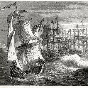
Photo Mug : Map of the Battle of Blenheim (or Blindheim), Hochstadt, Germany, 13 August 1704
, Hochstadt, Germany, 13 August 1704")
, Hochstadt, Germany, 13 August 1704")

![]()
Home Decor from Mary Evans Picture Library
Map of the Battle of Blenheim (or Blindheim), Hochstadt, Germany, 13 August 1704
Map of the Battle of Blenheim (or Blindheim), Hochstadt, Germany, 13 August 1704, part of the War of the Spanish Succession (1701-1714). Date: 1704
Mary Evans Picture Library makes available wonderful images created for people to enjoy over the centuries
Media ID 23463082
© Mary Evans Picture Library
1700s 1704 Alliance Blenheim Danube Layout Marlborough Succession Blindheim Hochstadt
Photo Mug
Step back in time with our Media Storehouse Photo Mug, featuring the iconic Map of the Battle of Blenheim by Terry Parker. This beautifully detailed map, taken from Mary Evans Prints Online, commemorates the historic clash between the Grand Alliance and the French forces on August 13, 1704, during the War of the Spanish Succession. Perfect for history enthusiasts, this mug is not just a drinkware, but a conversation starter and a piece of art. Embrace the past with every sip.
A personalised photo mug blends sentimentality with functionality, making an ideal gift for cherished loved ones, close friends, or valued colleagues. Preview may show both sides of the same mug.
Elevate your coffee or tea experience with our premium white ceramic mug. Its wide, comfortable handle makes drinking easy, and you can rely on it to be both microwave and dishwasher safe. Sold in single units, preview may show both sides of the same mug so you can see how the picture wraps around.
Mug Size is 8.1cm high x 9.6cm diameter (3.2" x 3.8")
These are individually made so all sizes are approximate
FEATURES IN THESE COLLECTIONS
> Mary Evans Prints Online
> New Images August 2021
> Arts
> Landscape paintings
> Waterfall and river artworks
> River artworks
> Europe
> Spain
> Related Images
> Historic
> Battles
> Related Images
> Maps and Charts
> Early Maps
> Maps and Charts
> Related Images
> Maps and Charts
> Spain
EDITORS COMMENTS
This striking map print depicts the Battle of Blenheim, also known as the Battle of Blindheim or the Battle of Hochstadt, which took place on August 13, 1704, during the War of the Spanish Succession (1701-1714). The battle is named after the German town of Blenheim, where the engagement took place near the Danube River. The event was a significant victory for the Grand Alliance, led by the Duke of Marlborough and Prince Eugen of Savoy, over the French army under the command of Marshal Tallard. The map provides a detailed layout of the battlefield, highlighting the strategic positions of the opposing forces and the course of the battle. The Danube River is prominently featured, with the French army initially crossing it to launch their surprise attack on the Allied forces. The map also shows the key topographical features of the area, such as woods, hills, and streams, which played a crucial role in the battle's outcome. The Battle of Blenheim was a turning point in the War of the Spanish Succession, as it marked the end of French military dominance in Europe and boosted the morale of the Grand Alliance. The victory also secured Marlborough's reputation as a military genius and led to his appointment as the Captain-General of the English Army. This map is an essential historical document that provides valuable insights into the military tactics and strategies employed during one of the most significant battles of the 18th century.
MADE IN AUSTRALIA
Safe Shipping with 30 Day Money Back Guarantee
FREE PERSONALISATION*
We are proud to offer a range of customisation features including Personalised Captions, Color Filters and Picture Zoom Tools
SECURE PAYMENTS
We happily accept a wide range of payment options so you can pay for the things you need in the way that is most convenient for you
* Options may vary by product and licensing agreement. Zoomed Pictures can be adjusted in the Cart.