Photo Mug > Europe > Italy > Maps
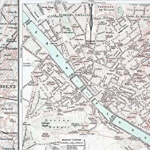
Photo Mug : Map of Italy in 1815. From the book Europe in the Nineteenth Century an Outline History, published 1916


![]()
Home Decor from Universal Images Group (UIG)
Map of Italy in 1815. From the book Europe in the Nineteenth Century an Outline History, published 1916
Universal Images Group (UIG) manages distribution for many leading specialist agencies worldwide
Media ID 20165315
© Universal Images Group
Photo Mug
Step back in time with our Media Storehouse Photo Mug featuring a captivating historical map of Italy from 1815. This vintage map, taken from the pages of Europe in the Nineteenth Century an Outline History published in 1916, showcases the political landscape of Italy during a pivotal period in European history. Each mug is expertly printed with archival-quality ink to preserve the intricate details of the map, ensuring a stunning visual display. Perfect for history enthusiasts, travelers, or anyone who appreciates the beauty of the past, this Photo Mug makes a unique and thoughtful gift. Embrace the rich history of Italy with every sip.
A personalised photo mug blends sentimentality with functionality, making an ideal gift for cherished loved ones, close friends, or valued colleagues. Preview may show both sides of the same mug.
Elevate your coffee or tea experience with our premium white ceramic mug. Its wide, comfortable handle makes drinking easy, and you can rely on it to be both microwave and dishwasher safe. Sold in single units, preview may show both sides of the same mug so you can see how the picture wraps around.
Mug Size is 9.6cm high x 8.1cm diameter (3.8" x 3.2")
These are individually made so all sizes are approximate
FEATURES IN THESE COLLECTIONS
> Maps and Charts
> Italy
> Maps and Charts
> Related Images
> Universal Images Group (UIG)
> History
> Historical Maps
EDITORS COMMENTS
This print showcases a remarkable piece of history - the Map of Italy in 1815. Taken from the renowned book "Europe in the Nineteenth Century an Outline History" published in 1916, this map offers a fascinating glimpse into Italy's political landscape during that era. With its intricate cartography and meticulous detailing, this map transports us back to a time when Italy was divided into various states and territories. Each region is clearly demarcated, allowing us to trace the borders and understand the complex dynamics that characterized Italian society at the time. The significance of this particular map lies not only in its historical value but also in its artistic presentation. The craftsmanship involved in creating such detailed maps is truly awe-inspiring, showcasing the skill and precision of Welsh cartographer Ken Welsh. As we study this image, we are reminded of how geography has played a crucial role throughout history. This map serves as a reminder that boundaries have shifted over time, nations have risen and fallen, yet our fascination with understanding our world remains constant. Thanks to Universal Images Group (UIG), we can now appreciate this stunning visual representation of Italy's geopolitical landscape from two centuries ago. It serves as both an educational tool for those interested in history and geography enthusiasts alike – offering insights into Italy's past while igniting curiosity about how it has evolved since then.
MADE IN AUSTRALIA
Safe Shipping with 30 Day Money Back Guarantee
FREE PERSONALISATION*
We are proud to offer a range of customisation features including Personalised Captions, Color Filters and Picture Zoom Tools
SECURE PAYMENTS
We happily accept a wide range of payment options so you can pay for the things you need in the way that is most convenient for you
* Options may vary by product and licensing agreement. Zoomed Pictures can be adjusted in the Cart.