Photo Mug > Maps and Charts > Related Images
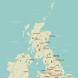
Photo Mug : Map of the United Kingdom


![]()
Home Decor from Universal Images Group (UIG)
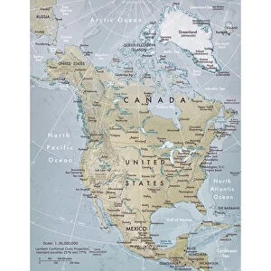
Map of the United Kingdom
Universal Images Group (UIG) manages distribution for many leading specialist agencies worldwide
Media ID 9539939
© Dorling Kindersley/UIG
Country European United Kingdom
Photo Mug
Bring a piece of the United Kingdom into your daily routine with our Media Storehouse Photo Mugs. Featuring an stunning image of a detailed map of the United Kingdom by Dorling Kindersley from Universal Images Group (UIG), these mugs are not just functional but also a great conversation starter. Each mug is carefully crafted with high-quality ceramics and advanced printing technology to ensure vibrant and long-lasting images. Perfect for tea or coffee, these mugs make a thoughtful gift for travel enthusiasts, history buffs, or anyone who loves the beauty of the United Kingdom. Order yours today and start your day with a beautiful reminder of this fascinating country.
A personalised photo mug blends sentimentality with functionality, making an ideal gift for cherished loved ones, close friends, or valued colleagues. Preview may show both sides of the same mug.
Elevate your coffee or tea experience with our premium white ceramic mug. Its wide, comfortable handle makes drinking easy, and you can rely on it to be both microwave and dishwasher safe. Sold in single units, preview may show both sides of the same mug so you can see how the picture wraps around.
Mug Size is 9.6cm high x 8.1cm diameter (3.8" x 3.2")
These are individually made so all sizes are approximate
FEATURES IN THESE COLLECTIONS
> Maps and Charts
> Related Images
> Universal Images Group (UIG)
> Illustrations
> Illustrations 1
EDITORS COMMENTS
This vibrant and detailed print showcases the "Map of the United Kingdom" created by Dorling Kindersley, a renowned publisher known for their exceptional cartography. The map beautifully captures the diverse landscape and rich history of this European country. From rolling green hills to bustling cities, every corner of the United Kingdom is meticulously illustrated in this stunning piece. The colors used in this map are vivid and eye-catching, making it an ideal addition to any space. Whether you're a geography enthusiast or simply appreciate artistry, this print will undoubtedly captivate your attention. It serves as both an educational tool and a decorative item, allowing you to explore the various regions that make up the United Kingdom from the comfort of your own home. With its intricate details and accurate representation, this map invites you on a visual journey through England, Scotland, Wales, and Northern Ireland. Discover famous landmarks like Big Ben in London or Edinburgh Castle in Scotland with just one glance at this comprehensive illustration. Perfect for travel enthusiasts or those who want to learn more about British geography, this print is not only aesthetically pleasing but also informative. Hang it on your wall or display it on your desk - either way; it's sure to spark conversations about culture, history, and exploration.
MADE IN AUSTRALIA
Safe Shipping with 30 Day Money Back Guarantee
FREE PERSONALISATION*
We are proud to offer a range of customisation features including Personalised Captions, Color Filters and Picture Zoom Tools
SECURE PAYMENTS
We happily accept a wide range of payment options so you can pay for the things you need in the way that is most convenient for you
* Options may vary by product and licensing agreement. Zoomed Pictures can be adjusted in the Cart.