Photographic Print > Europe > France > Canton > Nord
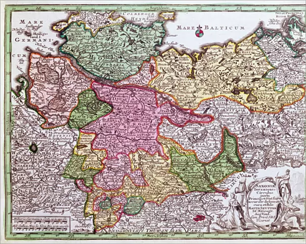
Photographic Print : Map of Northern Germany, from an Atlas (colour litho)
![]()

Photo Prints from Fine Art Finder
Map of Northern Germany, from an Atlas (colour litho)
CHT212762 Map of Northern Germany, from an Atlas (colour litho) by Seutter, Georg MatthAaus (1678-1757); Bibliotheque des Arts Decoratifs, Paris, France; eArchives Charmet; German, out of copyright
Media ID 22815670
© Archives Charmet / Bridgeman Images
Bavaria Baviere Carte Saxe Saxony
10"x8" (25x20cm) Photo Print
Discover the historical charm of Northern Germany with our exquisite Photographic Print of a Map from an Atlas by Seutter. This stunning colour lithograph, part of the Media Storehouse collection from Bridgeman Images, showcases intricate detail and vibrant colours. Originally published in the Bibliotheque des Arts Decoratifs in Paris, this out-of-copyright map is a captivating addition to any decor or collection, transporting you back in time. Bring history into your home or office with this beautiful and authentic piece of fine art.
Ideal for framing, Australian made Photo Prints are produced on high-quality 270 gsm lustre photo paper which has a subtle shimmer adding a touch of elegance, designed to enhance their visual appeal.
Our Photo Prints are in a large range of sizes and are printed on Archival Quality Paper for excellent colour reproduction and longevity. They are ideal for framing (our Framed Prints use these) at a reasonable cost. Alternatives include cheaper Poster Prints and higher quality Fine Art Paper, the choice of which is largely dependant on your budget.
Estimated Product Size is 25.4cm x 20.3cm (10" x 8")
These are individually made so all sizes are approximate
Artwork printed orientated as per the preview above, with landscape (horizontal) or portrait (vertical) orientation to match the source image.
FEATURES IN THESE COLLECTIONS
> Fine Art Finder
> Artists
> Georg Matthäus Seutter
> Fine Art Finder
> Artists
> German School
> Fine Art Finder
> Maps (celestial & Terrestrial)
> Europe
> France
> Canton
> Nord
> Europe
> France
> Paris
> Maps
> Europe
> France
> Paris
> Related Images
> Maps and Charts
> Early Maps
EDITORS COMMENTS
This print showcases a stunning "Map of Northern Germany" from an Atlas, created by the talented cartographer Georg Matthäus Seutter. With its vibrant colors and intricate details, this lithograph offers a glimpse into early modern Europe's geographical landscape. The map highlights various regions including Bavaria (Bavière) and Saxony (Saxe), providing historical context to these areas. Its artistic representation transports us back in time, allowing us to explore the northern part of Germany through the eyes of Seutter. Displayed at the Bibliotheque des Arts Decoratifs in Paris, France, this print captures the essence of German cartography during Seutter's era. The eArchives Charmet has preserved this piece as part of their collection, ensuring that its beauty can be appreciated for generations to come. As we delve into this remarkable artwork, we are reminded of how maps have played a crucial role in shaping our understanding of geography throughout history. This particular map not only serves as a navigational tool but also stands as a testament to Seutter's skillful craftsmanship and dedication to his craft. With its rich historical significance and visual allure, this print by Bridgeman Images is sure to captivate any admirer of art or history alike.
MADE IN AUSTRALIA
Safe Shipping with 30 Day Money Back Guarantee
FREE PERSONALISATION*
We are proud to offer a range of customisation features including Personalised Captions, Color Filters and Picture Zoom Tools
SECURE PAYMENTS
We happily accept a wide range of payment options so you can pay for the things you need in the way that is most convenient for you
* Options may vary by product and licensing agreement. Zoomed Pictures can be adjusted in the Cart.


