Photographic Print > Fine Art Storehouse > Map
Photographic Print : Algeria surroundings map 1895

![]()
Photo Prints from Fine Art Storehouse
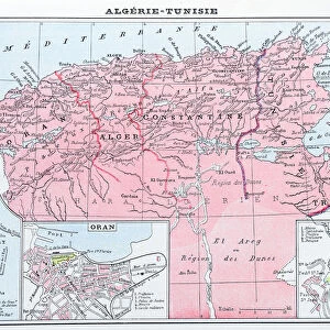
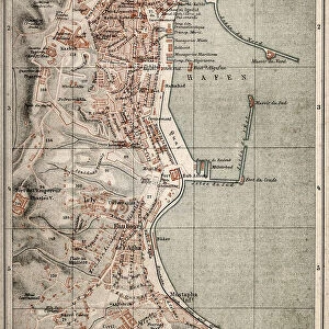
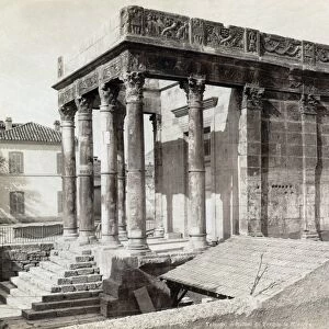
Algeria surroundings map 1895
Meyers Konversations-Lexikon. Ein Nachschlagewerk des allgemeinen Wissens, 5th edition 17 volumes Bibliographisches Institut - Leipzig 1895-1897
Unleash your creativity and transform your space into a visual masterpiece!
THEPALMER
Media ID 13611805
© This content is subject to copyright
Algeria Arabic Berber North Africa
15"x10" (37.5x25cm) Poster
Step back in time with our exquisite photographic print of "Algeria Surroundings Map 1895" from THEPALMER's collection at Media Storehouse. This stunning fine art print is taken from the pages of the prestigious Meyers Konversations-Lexikon, 5th edition published by Bibliographisches Institut in 1895-1897. The intricate details of the map illustrate the geography and political boundaries of Algeria during that era, making it a captivating addition to any history or cartography enthusiast's collection. Bring a piece of historical accuracy and intrigue into your home or office with this beautiful, museum-quality print.
High-quality poster prints are available in a range of sizes and are printed on 270 gsm semi-glossy silk finish poster paper. An affordable option for decorating any space, they are perfect for fixing straight onto walls. To ensure your poster arrives in good condition, we roll and send them in strong mailing tubes.
Our Photo Prints are in a large range of sizes and are printed on Archival Quality Paper for excellent colour reproduction and longevity. They are ideal for framing (our Framed Prints use these) at a reasonable cost. Alternatives include cheaper Poster Prints and higher quality Fine Art Paper, the choice of which is largely dependant on your budget.
Estimated Image Size (if not cropped) is 18.5cm x 37.5cm (7.3" x 14.8")
Estimated Product Size is 25cm x 37.5cm (9.8" x 14.8")
These are individually made so all sizes are approximate
Artwork printed orientated as per the preview above, with portrait (vertical) orientation to match the source image.
FEATURES IN THESE COLLECTIONS
> Fine Art Storehouse
> The Magical World of Illustration
> Palmer Illustrated Collection
> Fine Art Storehouse
> Map
> Historical Maps
> Fine Art Storehouse
> Map
> USA Maps
EDITORS COMMENTS
This print showcases a vintage map of Algeria's surroundings, dating back to 1895. Taken from the renowned Meyers Konversations-Lexikon, this piece is an exquisite representation of historical cartography. The intricate engraving and attention to detail transport us back in time, offering a glimpse into the rich cultural tapestry of North Africa. The map encompasses not only the capital city Algiers but also various regions inhabited by Arabic and Berber communities. Its vertical panoramic layout allows for a comprehensive view of Algeria's diverse landscapes and geographical features. From vast deserts to lush oases, this map captures the essence of this fascinating country. As we admire this illustration, we are reminded of the importance that maps hold in understanding our world's history and geography. They serve as windows into different eras, providing valuable insights into past civilizations and their connections with one another. "The Algerian Surroundings Map" by THEPALMER invites us on a visual journey through time while celebrating the artistry involved in creating such detailed engravings. Whether displayed in homes or offices, it serves as both an educational tool and a stunning piece of artwork that sparks curiosity about Algeria's past.
MADE IN AUSTRALIA
Safe Shipping with 30 Day Money Back Guarantee
FREE PERSONALISATION*
We are proud to offer a range of customisation features including Personalised Captions, Color Filters and Picture Zoom Tools
SECURE PAYMENTS
We happily accept a wide range of payment options so you can pay for the things you need in the way that is most convenient for you
* Options may vary by product and licensing agreement. Zoomed Pictures can be adjusted in the Cart.