Photographic Print > North America > Canada > Maps
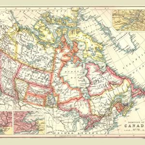
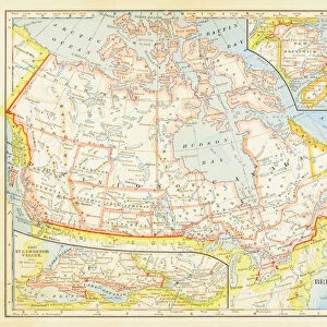
Photographic Print : Antique Map of Canada - 19th Century


![]()
Photo Prints from Fine Art Storehouse
Antique Map of Canada - 19th Century
Vintage map of Canada. Vintage etching circa late 19th century
Unleash your creativity and transform your space into a visual masterpiece!
powerofforever
Media ID 15149719
© This content is subject to copyright
10"x8" (25x20cm) Photo Print
Ideal for framing, Australian made Photo Prints are produced on high-quality 270 gsm lustre photo paper which has a subtle shimmer adding a touch of elegance, designed to enhance their visual appeal.
Our Photo Prints are in a large range of sizes and are printed on Archival Quality Paper for excellent colour reproduction and longevity. They are ideal for framing (our Framed Prints use these) at a reasonable cost. Alternatives include cheaper Poster Prints and higher quality Fine Art Paper, the choice of which is largely dependant on your budget.
Estimated Product Size is 25.4cm x 20.3cm (10" x 8")
These are individually made so all sizes are approximate
Artwork printed orientated as per the preview above, with landscape (horizontal) or portrait (vertical) orientation to match the source image.
FEATURES IN THESE COLLECTIONS
> Fine Art Storehouse
> Map
> Historical Maps
> Maps and Charts
> Related Images
> North America
> Canada
> Maps
> North America
> Canada
> Related Images
MADE IN AUSTRALIA
Safe Shipping with 30 Day Money Back Guarantee
FREE PERSONALISATION*
We are proud to offer a range of customisation features including Personalised Captions, Color Filters and Picture Zoom Tools
SECURE PAYMENTS
We happily accept a wide range of payment options so you can pay for the things you need in the way that is most convenient for you
* Options may vary by product and licensing agreement. Zoomed Pictures can be adjusted in the Cart.