Photographic Print > Africa > Egypt > Maps
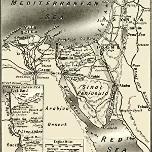
Photographic Print : Antique map of Lower Egypt


![]()
Photo Prints from Fine Art Storehouse
Antique map of Lower Egypt
Vintage map from 1861 of Lower Egypt showing the journeys of the Israelites
Unleash your creativity and transform your space into a visual masterpiece!
duncan1890
Media ID 18062783
© duncan1890
10"x8" (25x20cm) Photo Print
Step back in time with our exquisite antique map of Lower Egypt from the Media Storehouse Fine Art collection. This vintage masterpiece, created by duncan1890 in 1861, offers a captivating glimpse into history as it illustrates the journeys of the Israelites. Add an air of sophistication and intrigue to your home or office with this beautifully preserved, museum-quality print. Each print is carefully crafted using high-definition technology to ensure vibrant colors and stunning detail, making it a must-have for history enthusiasts and art collectors alike.
Ideal for framing, Australian made Photo Prints are produced on high-quality 270 gsm lustre photo paper which has a subtle shimmer adding a touch of elegance, designed to enhance their visual appeal.
Our Photo Prints are in a large range of sizes and are printed on Archival Quality Paper for excellent colour reproduction and longevity. They are ideal for framing (our Framed Prints use these) at a reasonable cost. Alternatives include cheaper Poster Prints and higher quality Fine Art Paper, the choice of which is largely dependant on your budget.
Estimated Image Size (if not cropped) is 25.4cm x 18.1cm (10" x 7.1")
Estimated Product Size is 25.4cm x 20.3cm (10" x 8")
These are individually made so all sizes are approximate
Artwork printed orientated as per the preview above, with landscape (horizontal) orientation to match the source image.
FEATURES IN THESE COLLECTIONS
> Fine Art Storehouse
> Map
> Historical Maps
> Africa
> Egypt
> Related Images
> Historic
> Ancient civilizations
> Ancient Egypt
> Historic
> Ancient civilizations
> Maps and Charts
> Early Maps
> Maps and Charts
> Related Images
EDITORS COMMENTS
This print takes us on a journey back in time to the ancient land of Lower Egypt. Displayed before our eyes is an exquisite vintage map, meticulously crafted in 1861 by an unknown cartographer. This remarkable piece showcases the intricate journeys undertaken by the Israelites during their historic sojourn through this region. The map itself is a testament to both artistry and historical significance. Its delicate details and faded hues transport us to a time when cartography was not only a scientific pursuit but also an artistic expression. As we gaze upon its carefully drawn borders, rivers, and cities, we are reminded of the rich tapestry of civilizations that once flourished across these lands. Lower Egypt's role as a cradle of ancient civilization becomes evident as we study this antique map further. It whispers tales of pharaohs reigning over mighty kingdoms, bustling trade routes connecting distant lands, and cultural exchanges shaping human history. Duncan1890's expertly captured photograph allows us to appreciate every nuance and intricacy present within this historical artifact. The fine details preserved in this print awaken our curiosity about past eras while serving as a reminder that even centuries-old maps can still hold relevance today. Whether you are fascinated by Middle Eastern history or simply captivated by the beauty of antique maps, this stunning print will undoubtedly add depth and intrigue to any space it graces.
MADE IN AUSTRALIA
Safe Shipping with 30 Day Money Back Guarantee
FREE PERSONALISATION*
We are proud to offer a range of customisation features including Personalised Captions, Color Filters and Picture Zoom Tools
SECURE PAYMENTS
We happily accept a wide range of payment options so you can pay for the things you need in the way that is most convenient for you
* Options may vary by product and licensing agreement. Zoomed Pictures can be adjusted in the Cart.