Photographic Print > North America > United States of America > New York > New York > Maps
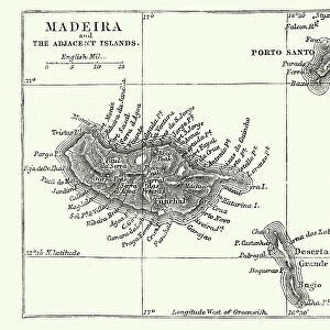
Photographic Print : Madeira island map 1883


![]()
Photo Prints from Fine Art Storehouse
Madeira island map 1883
Encyclopedia Britannica 9th Edition New York Samuel L. Hall 1883 Vol XV
Unleash your creativity and transform your space into a visual masterpiece!
THEPALMER
Media ID 14756780
© This content is subject to copyright
10"x8" (25x20cm) Photo Print
Discover the rich history of Madeira Island with our exquisite "Madeira Island Map 1883" photographic print from ThePalmer at Fine Art Storehouse. This stunning reproduction is derived from the Encyclopedia Britannica 9th Edition, New York, published in 1883 by Samuel L. Hall. Travel back in time as you admire the intricate details of this vintage map, showcasing the islands and coastal features as they appeared over a century ago. Bring a piece of historical cartography into your home or office, and add an air of classic sophistication to your space. Perfect for those who appreciate the beauty of the past and the art of cartography.
Ideal for framing, Australian made Photo Prints are produced on high-quality 270 gsm lustre photo paper which has a subtle shimmer adding a touch of elegance, designed to enhance their visual appeal.
Our Photo Prints are in a large range of sizes and are printed on Archival Quality Paper for excellent colour reproduction and longevity. They are ideal for framing (our Framed Prints use these) at a reasonable cost. Alternatives include cheaper Poster Prints and higher quality Fine Art Paper, the choice of which is largely dependant on your budget.
Estimated Product Size is 25.4cm x 20.3cm (10" x 8")
These are individually made so all sizes are approximate
Artwork printed orientated as per the preview above, with landscape (horizontal) orientation to match the source image.
FEATURES IN THESE COLLECTIONS
> Fine Art Storehouse
> Map
> Historical Maps
> Maps and Charts
> Related Images
> North America
> United States of America
> New York
> New York
> Maps
> North America
> United States of America
> New York
> Related Images
EDITORS COMMENTS
In this photo print, titled "Madeira Island Map 1883" we are transported back in time to the late 19th century. The image showcases a meticulously detailed map of Madeira Island, taken from the Encyclopedia Britannica's 9th Edition published in New York by Samuel L. Hall in 1883. The map itself is a testament to the artistry and precision of cartography during that era. Every contour line, river, and coastal feature is intricately depicted with remarkable accuracy. It offers viewers a glimpse into the geographical layout of Madeira Island as it was known over a century ago. As we study this historical artifact, our imagination takes flight as we envision explorers and adventurers using similar maps to navigate their way through uncharted territories. We can almost feel their excitement and anticipation as they set sail towards new horizons. "ThePALMER" has expertly captured this piece of history through his lens, preserving its delicate details for generations to come. The composition is visually striking with its sepia tones evoking nostalgia while enhancing the vintage aesthetic. Whether you have an affinity for cartography or simply appreciate fine art photography, this print serves as both an educational tool and a beautiful decorative piece for any space. It invites us to reflect on how far we've come while honoring the rich heritage embedded within these antique maps.
MADE IN AUSTRALIA
Safe Shipping with 30 Day Money Back Guarantee
FREE PERSONALISATION*
We are proud to offer a range of customisation features including Personalised Captions, Color Filters and Picture Zoom Tools
SECURE PAYMENTS
We happily accept a wide range of payment options so you can pay for the things you need in the way that is most convenient for you
* Options may vary by product and licensing agreement. Zoomed Pictures can be adjusted in the Cart.