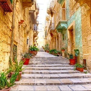
Photographic Print > Africa > Egypt > Maps
Photographic Print : Map of Egypt and Darfur 1900


![]()
Photo Prints from Fine Art Storehouse
Map of Egypt and Darfur 1900
Meyers hand-Atlas Leipzig und Wien Verlag des Bibliographischen Instituts 1900
Unleash your creativity and transform your space into a visual masterpiece!
THEPALMER
Media ID 18106889
© 2014 Roberto Adrian Photography
10"x8" (25x20cm) Photo Print
Discover the rich history of Egypt and Darfur with this exquisite vintage map print from Media Storehouse's Fine Art Storehouse collection. Titled "Map of Egypt and Darfur 1900" by THEPALMER, this beautifully detailed print is taken from the esteemed Meyers Hand-Atlas published by the Bibliographischen Institut in Leipzig and Wien. Transport yourself back in time as you admire the intricate cartography and historical accuracy of this rare and captivating piece. Add a touch of history and elegance to your home or office décor with this unique and authentic fine art print.
Ideal for framing, Australian made Photo Prints are produced on high-quality 270 gsm lustre photo paper which has a subtle shimmer adding a touch of elegance, designed to enhance their visual appeal.
Our Photo Prints are in a large range of sizes and are printed on Archival Quality Paper for excellent colour reproduction and longevity. They are ideal for framing (our Framed Prints use these) at a reasonable cost. Alternatives include cheaper Poster Prints and higher quality Fine Art Paper, the choice of which is largely dependant on your budget.
Estimated Product Size is 20.3cm x 25.4cm (8" x 10")
These are individually made so all sizes are approximate
Artwork printed orientated as per the preview above, with landscape (horizontal) or portrait (vertical) orientation to match the source image.
FEATURES IN THESE COLLECTIONS
> Fine Art Storehouse
> Map
> Historical Maps
> Africa
> Egypt
> Related Images
EDITORS COMMENTS
This print titled "Map of Egypt and Darfur 1900" takes us on a visual journey back in time to the turn of the 20th century. The map, originally published in Meyers hand-Atlas Leipzig und Wien Verlag des Bibliographischen Instituts in 1900, offers a fascinating glimpse into the geopolitical landscape of Egypt and Darfur during that era. The intricate details depicted on this vintage map are truly remarkable. Every contour line, river, city, and border has been meticulously etched onto its surface by skilled cartographers of yesteryears. As we examine it closely, we can almost feel ourselves being transported to an era where exploration and discovery were at their peak. Egypt's iconic Nile River dominates the center stage as it winds its way through ancient cities such as Cairo and Luxor. Surrounding it are vast stretches of desert sands that seem to hold countless untold stories within their dunes. Towards the west lies Darfur, with its own unique topography waiting to be explored. "The Palmer" whose name is associated with this beautiful print from Fine Art Storehouse, has managed to capture not only historical accuracy but also a sense of nostalgia through his expert reproduction techniques. This photograph allows us to appreciate both the artistry involved in creating these maps and their significance as valuable historical artifacts. Whether you're a history enthusiast or simply captivated by the beauty of vintage cartography, this print serves as a stunning reminder of how our world has evolved
MADE IN AUSTRALIA
Safe Shipping with 30 Day Money Back Guarantee
FREE PERSONALISATION*
We are proud to offer a range of customisation features including Personalised Captions, Color Filters and Picture Zoom Tools
SECURE PAYMENTS
We happily accept a wide range of payment options so you can pay for the things you need in the way that is most convenient for you
* Options may vary by product and licensing agreement. Zoomed Pictures can be adjusted in the Cart.