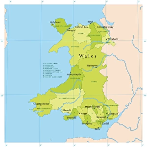
Photographic Print > Europe > United Kingdom > Wales > Maps
Photographic Print : Map of England and Wales 1896


![]()
Photo Prints from Fine Art Storehouse
Map of England and Wales 1896
Andres Allgemeiner Handatlas - Bielefeld und Leipzig 1896
Unleash your creativity and transform your space into a visual masterpiece!
THEPALMER
Media ID 18356829
10"x8" (25x20cm) Photo Print
Step back in time with our exquisite 'Map of England and Wales 1896' print from THEPALMER's Fine Art Storehouse collection. This captivating historical map, published by Andres in Bielefeld and Leipzig, transports you back to a bygone era. Meticulously preserved, the intricate details of the map showcase the geographical landscape of England and Wales as it was over a century ago. A perfect addition to any home or office, this vintage map print adds an air of sophistication and historical charm. Bring history to life with this stunning piece of art.
Ideal for framing, Australian made Photo Prints are produced on high-quality 270 gsm lustre photo paper which has a subtle shimmer adding a touch of elegance, designed to enhance their visual appeal.
Our Photo Prints are in a large range of sizes and are printed on Archival Quality Paper for excellent colour reproduction and longevity. They are ideal for framing (our Framed Prints use these) at a reasonable cost. Alternatives include cheaper Poster Prints and higher quality Fine Art Paper, the choice of which is largely dependant on your budget.
Estimated Product Size is 25.4cm x 20.3cm (10" x 8")
These are individually made so all sizes are approximate
Artwork printed orientated as per the preview above, with landscape (horizontal) or portrait (vertical) orientation to match the source image.
FEATURES IN THESE COLLECTIONS
> Fine Art Storehouse
> Map
> Historical Maps
> Europe
> United Kingdom
> England
> Maps
> Europe
> United Kingdom
> England
> Posters
> Europe
> United Kingdom
> England
> Related Images
> Europe
> United Kingdom
> Wales
> Maps
> Europe
> United Kingdom
> Wales
> Posters
> Europe
> United Kingdom
> Wales
> Related Images
> Maps and Charts
> Related Images
> Maps and Charts
> Wales
EDITORS COMMENTS
This print showcases a remarkable piece of history - the "Map of England and Wales 1896" from Andres Allgemeiner Handatlas. A true treasure for cartography enthusiasts, this vintage map takes us back to a bygone era, offering a glimpse into the past. Crafted with meticulous detail, every inch of this map is filled with intricate lines and delicate typography, showcasing the artistry that went into its creation. The rich colors and ornate borders add an air of elegance to this historical artifact. As we explore this map, we are transported to late 19th-century England and Wales. We can trace our fingers along the familiar outlines of cities like London, Manchester, or Cardiff while discovering lesser-known towns tucked away in rural landscapes. Rivers meander gracefully across the paper canvas as they wind through picturesque countryside scenes. Beyond its aesthetic appeal lies a wealth of information waiting to be discovered. This map serves as a testament to human curiosity and exploration during an era when travel was still largely dependent on traditional means such as railways and horse-drawn carriages. Whether displayed in a study or adorning the walls of an avid collector's gallery, this print offers both beauty and historical significance. It invites us to reflect upon how these lands have evolved over time while reminding us that even in today's digital age, there is something undeniably enchanting about holding a tangible piece of history in our hands.
MADE IN AUSTRALIA
Safe Shipping with 30 Day Money Back Guarantee
FREE PERSONALISATION*
We are proud to offer a range of customisation features including Personalised Captions, Color Filters and Picture Zoom Tools
SECURE PAYMENTS
We happily accept a wide range of payment options so you can pay for the things you need in the way that is most convenient for you
* Options may vary by product and licensing agreement. Zoomed Pictures can be adjusted in the Cart.