Photographic Print > Europe > Poland > Maps
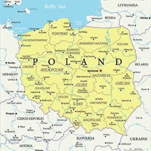
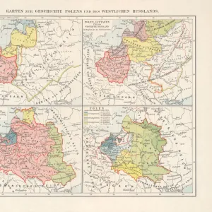
Photographic Print : Map of Kingdom of Poland from 18th century


![]()
Photo Prints from Fine Art Storehouse
Map of Kingdom of Poland from 18th century
Illustration of a Map of Kingdom of Poland from 18th century
Unleash your creativity and transform your space into a visual masterpiece!
Nastasic
Media ID 18356645
10"x8" (25x20cm) Photo Print
Discover the rich history of Poland with our exquisite "Map of the Kingdom of Poland from the 18th Century" print by Nastasic, available now at Media Storehouse. This stunning piece of historical art transports you back in time, showcasing intricate details of the Polish territory during an era of great cultural and political significance. Perfect for history enthusiasts, scholars, or anyone seeking to adorn their walls with a unique and educational piece, this fine art print is a must-have addition to your collection. Bring the past to life in your home or office with the timeless beauty of this historical map. Order yours today from the Fine Art Storehouse at Media Storehouse.
Ideal for framing, Australian made Photo Prints are produced on high-quality 270 gsm lustre photo paper which has a subtle shimmer adding a touch of elegance, designed to enhance their visual appeal.
Our Photo Prints are in a large range of sizes and are printed on Archival Quality Paper for excellent colour reproduction and longevity. They are ideal for framing (our Framed Prints use these) at a reasonable cost. Alternatives include cheaper Poster Prints and higher quality Fine Art Paper, the choice of which is largely dependant on your budget.
Estimated Product Size is 25.4cm x 20.3cm (10" x 8")
These are individually made so all sizes are approximate
Artwork printed orientated as per the preview above, with landscape (horizontal) orientation to match the source image.
FEATURES IN THESE COLLECTIONS
> Fine Art Storehouse
> Map
> Historical Maps
> Europe
> Poland
> Related Images
> Maps and Charts
> Related Images
EDITORS COMMENTS
This print showcases an exquisite illustration of a Map of the Kingdom of Poland from the 18th century. A true masterpiece by Nastasic, this artwork takes us on a journey back in time to explore the rich history and grandeur of this once-mighty kingdom. The map itself is a testament to the skilled craftsmanship and attention to detail prevalent during that era. Every inch is meticulously adorned with intricate drawings, vibrant colors, and delicate calligraphy, offering a glimpse into the geographical boundaries and political divisions that shaped Poland at that time. As we delve deeper into this visual treasure trove, our eyes are drawn to notable landmarks such as regal castles, bustling cities, winding rivers, and lush forests. Each element tells its own story; each stroke of the artist's brush breathes life into forgotten tales of conquests, alliances, and cultural heritage. Beyond its aesthetic appeal lies an educational value that transcends centuries. This map serves as both a historical document for scholars seeking insights into Poland's past and an enchanting piece for art enthusiasts captivated by its sheer beauty. Whether displayed in homes or institutions alike, this print invites viewers to immerse themselves in Polish history while marveling at Nastasic's artistic prowess. It is not just an image frozen in time but rather a gateway connecting present-day observers with generations long gone – reminding us all of the enduring power held within works of fine art like this one.
MADE IN AUSTRALIA
Safe Shipping with 30 Day Money Back Guarantee
FREE PERSONALISATION*
We are proud to offer a range of customisation features including Personalised Captions, Color Filters and Picture Zoom Tools
SECURE PAYMENTS
We happily accept a wide range of payment options so you can pay for the things you need in the way that is most convenient for you
* Options may vary by product and licensing agreement. Zoomed Pictures can be adjusted in the Cart.