Photographic Print > Maps and Charts > Americas
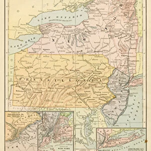
Photographic Print : Map of middle atlantic states 1889


![]()
Photo Prints from Fine Art Storehouse
Map of middle atlantic states 1889
Comprehensive Geography by James Monteith - American Book Company 1882, 1889
Unleash your creativity and transform your space into a visual masterpiece!
THEPALMER
Media ID 18357255
10"x8" (25x20cm) Photo Print
Step back in time with our exquisite 'Map of Middle Atlantic States 1889' print from THEPALMER's collection at Media Storehouse. This captivating piece is taken from the Comprehensive Geography book published by the American Book Company in 1882 and 1889. Transport yourself to a bygone era with this intricately detailed map, showcasing the Middle Atlantic States in the late 19th century. A stunning addition to any home or office decor, this fine art print is sure to spark conversation and inspire curiosity. Bring history to life with Media Storehouse's wide range of high-quality photographic prints.
Ideal for framing, Australian made Photo Prints are produced on high-quality 270 gsm lustre photo paper which has a subtle shimmer adding a touch of elegance, designed to enhance their visual appeal.
Our Photo Prints are in a large range of sizes and are printed on Archival Quality Paper for excellent colour reproduction and longevity. They are ideal for framing (our Framed Prints use these) at a reasonable cost. Alternatives include cheaper Poster Prints and higher quality Fine Art Paper, the choice of which is largely dependant on your budget.
Estimated Product Size is 20.3cm x 25.4cm (8" x 10")
These are individually made so all sizes are approximate
Artwork printed orientated as per the preview above, with landscape (horizontal) or portrait (vertical) orientation to match the source image.
FEATURES IN THESE COLLECTIONS
> Fine Art Storehouse
> Map
> Historical Maps
> Maps and Charts
> Related Images
EDITORS COMMENTS
In this print titled "Map of Middle Atlantic States 1889" we are transported back in time to an era when cartography was a meticulous art form. The map, originally featured in James Monteith's Comprehensive Geography published by the American Book Company in 1882 and updated in 1889, offers us a glimpse into the geographical landscape of the Middle Atlantic region during that period. The intricate details and vibrant colors of this vintage map immediately catch our attention. From the majestic Appalachian Mountains stretching across several states to the meandering rivers that carve their way through lush valleys, every contour is meticulously depicted. Towns and cities dotting the landscape serve as reminders of human settlement and progress amidst nature's grandeur. As we study this historical artifact, we can't help but marvel at how much has changed over time. Boundaries have shifted, new roads have been built, and urban centers have expanded exponentially since then. Yet there is something timeless about maps like these – they not only provide valuable information but also evoke a sense of wonderment for explorers past and present. "The Map of Middle Atlantic States 1889" serves as both a testament to human curiosity about our surroundings and an exquisite piece of artwork capturing an important chapter in America's geographic history. Displayed proudly on any wall or desk space, it invites us to reflect on our connection with the land beneath our feet while appreciating the craftsmanship involved in its creation.
MADE IN AUSTRALIA
Safe Shipping with 30 Day Money Back Guarantee
FREE PERSONALISATION*
We are proud to offer a range of customisation features including Personalised Captions, Color Filters and Picture Zoom Tools
SECURE PAYMENTS
We happily accept a wide range of payment options so you can pay for the things you need in the way that is most convenient for you
* Options may vary by product and licensing agreement. Zoomed Pictures can be adjusted in the Cart.