Photographic Print > Asia > Palestine > Maps
Photographic Print : Map of Palestine 1900


![]()
Photo Prints from Fine Art Storehouse
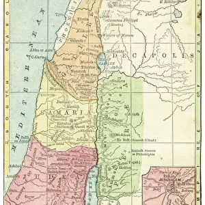
Map of Palestine 1900
Meyers hand-Atlas Leipzig und Wien Verlag des Bibliographischen Instituts 1900
Unleash your creativity and transform your space into a visual masterpiece!
THEPALMER
Media ID 18106877
© 2014 Roberto Adrian Photography
10"x8" (25x20cm) Photo Print
Step back in time with our exquisite 'Map of Palestine 1900' print from THEPALMER at Media Storehouse. Hailing from the renowned Meyers Hand-Atlas published by the Bibliographisches Institut in Leipzig and Wien, this fine art print showcases historical cartography at its finest. The intricate details of the map reveal the political and geographical landscape of the region over a century ago, making it a captivating addition to any space. Bring a piece of history into your home or office with this stunning, museum-quality print from the Fine Art Storehouse at Media Storehouse.
Ideal for framing, Australian made Photo Prints are produced on high-quality 270 gsm lustre photo paper which has a subtle shimmer adding a touch of elegance, designed to enhance their visual appeal.
Our Photo Prints are in a large range of sizes and are printed on Archival Quality Paper for excellent colour reproduction and longevity. They are ideal for framing (our Framed Prints use these) at a reasonable cost. Alternatives include cheaper Poster Prints and higher quality Fine Art Paper, the choice of which is largely dependant on your budget.
Estimated Product Size is 20.3cm x 25.4cm (8" x 10")
These are individually made so all sizes are approximate
Artwork printed orientated as per the preview above, with portrait (vertical) orientation to match the source image.
FEATURES IN THESE COLLECTIONS
> Fine Art Storehouse
> Map
> Historical Maps
> Asia
> Palestine
> Related Images
EDITORS COMMENTS
In this print titled "Map of Palestine 1900". THEPALMER takes us on a historical journey back to the turn of the century. The image showcases a meticulously detailed map from Meyers hand-Atlas Leipzig und Wien Verlag des Bibliographischen Instituts, published in 1900. The map itself is a testament to cartographic artistry, with intricate lines and delicate shading that bring to life the geography of Palestine as it was known at that time. It serves as a visual window into an era when borders were different, and political landscapes were yet to be reshaped. As we gaze upon this vintage masterpiece, our imagination transports us to an era where exploration and discovery were paramount. We can almost feel the excitement of early explorers who embarked on perilous journeys through uncharted territories, documenting their findings for future generations. Beyond its artistic allure, this photograph print holds immense historical significance. It offers a glimpse into how perceptions of land ownership have evolved over time while reminding us of the rich cultural heritage embedded within these ancient lands. "The Map of Palestine 1900" invites viewers to reflect upon history's impact on our present reality and encourages dialogue about geopolitical changes throughout time. As we contemplate this remarkable piece by THEPALMER, let it serve as a reminder that every map tells a story - one that intertwines human experiences with the ever-changing dynamics of our world.
MADE IN AUSTRALIA
Safe Shipping with 30 Day Money Back Guarantee
FREE PERSONALISATION*
We are proud to offer a range of customisation features including Personalised Captions, Color Filters and Picture Zoom Tools
SECURE PAYMENTS
We happily accept a wide range of payment options so you can pay for the things you need in the way that is most convenient for you
* Options may vary by product and licensing agreement. Zoomed Pictures can be adjusted in the Cart.